|
search place name
|
||
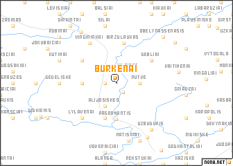
Burkėnai (Lithuania)Burkėnai is a town in Lithuania. An overview map of the region around Burkėnai is displayed below.
regional and 3d topo map of Burkėnai, Lithuania ::
Burkėnai airports ::
The nearest airport is KGD - Kaliningrad Khrabrovo, located 119.9 km south west of Burkėnai.
Nearby towns ::
Kreiviai (1.5km south) //
Plerpės (1.1km west) //
Mišučiai (2.1km north west) //
Kilpinės (2.1km north east) //
Pūtvė (2.1km east) //
Alijošiškės (3.9km south) //
Ryškas (3.2km west) //
Pagramantis (5.7km south) //
Kuturiai (5.7km south) //
Naujininkai (5.7km south) //
Biržu Laukas (6.4km north) //
Debliai (4.9km north east) //
Jucaičiai (4.9km north west) //
Vingininkai (6.8km north) //
Lylavėnai (6.4km south west) //
Užbūdupis (8.1km south east) //
Sungailiškiai (9.1km south) //
Šilalė (8.8km north) //
Obelynas Senasis (8.5km north east) //
[all distances 'as the bird flies' and approximate]  Places with similar names to Burkėnai, Lithuania ::
Disclaimer :: Information on this page comes without warranty of any kind |
||
|
Where is Burkėnai? Elevation and coordinates ::
Latitude (lat): 55°25'0"N Longitude (lon): 22°14'0"E
Elevation (approx.): 77m (map arrows pan, magnifying glasses zoom) |
||
|
Visiting Burkėnai? Hotel/Accommodation ::
Book a hotel in Burkėnai Travel Guide ::
Buy a travel guide for Lithuania rental cars ::
car rental offers GPS waypoint ::
download a GPX waypoint (PoI) of Burkėnai for your GPS receiver
|
||