|
search place name
|
||
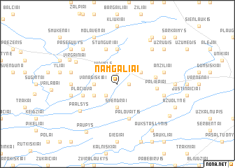
Namgaliai (Lithuania)Namgaliai is a town in Lithuania. An overview map of the region around Namgaliai is displayed below.
regional and 3d topo map of Namgaliai, Lithuania ::
Nearby towns ::
Blinstrubiškiai (1.1km east) //
Latakai (1.9km north) //
Vejukai (2.1km south west) //
Viduklė (2.5km north west) //
Švendrai (3.7km south) //
Vanagiškiai (2.1km west) //
Antapusinis (2.1km west) //
Lakstučiai (2.8km north east) //
Kelmynė (2.8km south west) //
Jūkainiai (5.6km north) //
Palovaitis (5.7km south) //
Plačiuva (3.7km south west) //
Stunguriai (5.7km north) //
Papelkiai (3.6km east) //
Paliepiai (3.6km east) //
Paalsys (5.5km south west) //
Kanopėnai (4.2km west) //
Virgainiai (5.1km north west) //
Sujainiai (4.6km south east) //
Anžiliai (4.6km north east) //
Apusinai (4.6km south west) //
Aleknai (4.6km north west) //
Griaužai (6.4km north west) //
Didvėjis (6.4km north east) //
Molavėnai (7.7km north) //
Aukštkėliai (5.8km north west) //
Gyliai (7.6km north east) //
Paupys (8.2km south) //
Aukštašlynis (8.1km south east) //
[all distances 'as the bird flies' and approximate]  Places with similar names to Namgaliai, Lithuania ::
Disclaimer :: Information on this page comes without warranty of any kind |
||
|
Where is Namgaliai? Elevation and coordinates ::
Latitude (lat): 55°23'0"N Longitude (lon): 22°55'0"E
Elevation (approx.): 75m (map arrows pan, magnifying glasses zoom) |
||
|
Visiting Namgaliai? Hotel/Accommodation ::
Book a hotel in Namgaliai Travel Guide ::
Buy a travel guide for Lithuania rental cars ::
car rental offers GPS waypoint ::
download a GPX waypoint (PoI) of Namgaliai for your GPS receiver
|
||