|
search place name
|
||
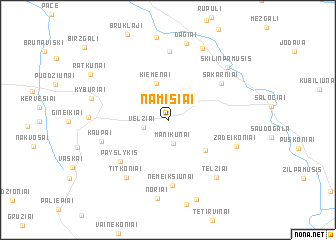
Namišiai (Panevėžio Apskritis, Lithuania)Namišiai is a town in the Panevėžio Apskritis region of Lithuania. An overview map of the region around Namišiai is displayed below.
regional and 3d topo map of Namišiai, Lithuania ::
Nearby towns ::
Manikūnai (2.6km south) //
Velžiai (1.7km south west) //
Kiemėnai (4.2km north) //
Purviai (4.0km south east) //
Payslykis (5.4km south west) //
Nemeikšiūnai (7.2km south) //
Šakarniai (5.3km north east) //
Namajūnai (7.7km north) //
Kaupai (4.7km south west) //
Titkoniai (6.9km south west) //
Žadeikoniai (5.1km south east) //
Telžiai (7.0km south east) //
Noriai (8.7km south) //
Dagiai (8.7km north) //
Škilinpamušis (6.9km north east) //
Kyburiai (5.3km north west) //
Eidžiotoniai (4.9km west) //
Baltpamusė (8.3km north) //
Baravykynė (8.9km south) //
Ratkūnai (7.0km north west) //
[all distances 'as the bird flies' and approximate]  Places with similar names to Namišiai, Lithuania ::
// Namchaw (MM)
// Namhsio (MM)
// Namsio (MM)
// Neumeichow (DE)
// Numšiai (LT)
// Nemcha (RU)
// Nioumachoua (KM)
// Nambashi (IN)
// Namchi (IN)
// Nimach (IN)
Disclaimer :: Information on this page comes without warranty of any kind |
||
|
Where is Namišiai? Elevation and coordinates ::
Latitude (lat): 56°12'50"N Longitude (lon): 24°18'26"E
Elevation (approx.): 39m (map arrows pan, magnifying glasses zoom) |
||
|
Visiting Namišiai? Hotel/Accommodation ::
Book a hotel in Namišiai Travel Guide ::
Buy a travel guide for Lithuania rental cars ::
car rental offers GPS waypoint ::
download a GPX waypoint (PoI) of Namišiai for your GPS receiver
|
||