|
search place name
|
||
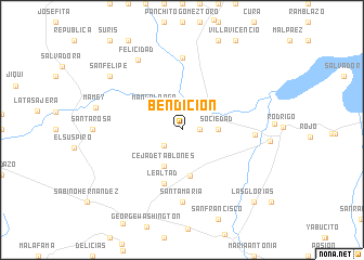
Bendición (Villa Clara, Cuba)Bendición is a town in the Villa Clara region of Cuba. An overview map of the region around Bendición is displayed below.
regional and 3d topo map of Bendición, Cuba ::
Bendición airports ::
The nearest airport is SNU - Santa Clara Abel Santamaria, located 40.8 km south east of Bendición.
Other airports nearby include CFG - Cienfuegos Jaime Gonzalez (60.6 km south), VRA - Varadero Juan Gualberto Gomez Intl (124.5 km west), AVI - Ciego De Avila Maximo Gomez (170.2 km south east), CYO - Cayo Vilo Acuna Intl (175.8 km south west), Nearby towns ::
Olayita (1.7km east) //
Bordón (2.3km south west) //
Manga Larga (3.4km north west) //
Sociedad (3.4km east) //
Ceja de Tablones (4.1km south west) //
Bermeja (4.8km south) //
Lealtad (5.8km south) //
La Panchita (7.4km south) //
Santa María (7.4km south) //
Santa Isabel de Itabo (7.4km north) //
Pepilla (7.0km east) //
Felicidad (8.4km north west) //
San Felipe (8.8km north west) //
Las Glorias (10.1km south east) //
[all distances 'as the bird flies' and approximate]  Places with similar names to Bendición, Cuba ::
// Bandayzān (IQ)
// Bendosen (NO)
// Ban Du Son (TH)
// Ban Ta Son (TH)
// Bandzinai I (LT)
// Bandzinai II (LT)
// Bintosun (TR)
// Bandāzān (IR)
// Bandzounou (CG)
// Bintasan (MY)
Disclaimer :: Information on this page comes without warranty of any kind |
||
|
Where is Bendición? Elevation and coordinates ::
Latitude (lat): 22°41'0"N Longitude (lon): 80°17'0"W
Elevation (approx.): 45m (map arrows pan, magnifying glasses zoom) |
||
|
Visiting Bendición? Hotel/Accommodation ::
Book a hotel in Bendición Travel Guide ::
Buy a travel guide for Cuba rental cars ::
car rental offers GPS waypoint ::
download a GPX waypoint (PoI) of Bendición for your GPS receiver
|
||