|
search place name
|
||
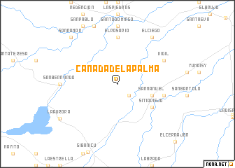
Cañada de la Palma (Camagüey, Cuba)Cañada de la Palma is a town in the Camagüey region of Cuba. An overview map of the region around Cañada de la Palma is displayed below.
regional and 3d topo map of Cañada de la Palma, Cuba ::
Cañada de la Palma airports ::
The nearest airport is CMW - Camaguey Ignacio Agramonte Intl, located 39.0 km west of Cañada de la Palma.
Other airports nearby include VTU - Las Tunas Hermanos Ameijeiras (68.5 km south east), MZO - Manzanillo Sierra Maestra (122.8 km south), HOG - Holguin Frank Pais Intl (135.7 km south east), BYM - Bayamo Carlos Manuel De Cespedes (137.1 km south east), Nearby towns ::
Oriente Rebelde (2.5km south east) //
San Manuel (5.5km east) //
Sitio Viejo (6.4km south east) //
El Rosario (7.4km north) //
El Quemado (7.4km north) //
La Caridad (7.2km east) //
Vigil (7.8km north east) //
El Ciego (9.0km north east) //
San Ramón (10.1km north west) //
Las Mercedes (10.1km north west) //
[all distances 'as the bird flies' and approximate] 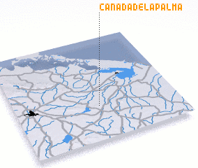 Places with similar names to Cañada de la Palma, Cuba ::
// Cañada de la Palma (DO)
Disclaimer :: Information on this page comes without warranty of any kind |
||
|
Where is Cañada de la Palma? Elevation and coordinates ::
Latitude (lat): 21°20'0"N Longitude (lon): 77°29'0"W
Elevation (approx.): 46m (map arrows pan, magnifying glasses zoom) |
||
|
Visiting Cañada de la Palma? Hotel/Accommodation ::
Book a hotel in Cañada de la Palma Travel Guide ::
Buy a travel guide for Cuba rental cars ::
car rental offers GPS waypoint ::
download a GPX waypoint (PoI) of Cañada de la Palma for your GPS receiver
|
||