|
search place name
|
||
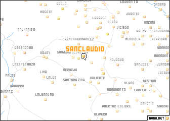
San Claudio (Matanzas, Cuba)San Claudio is a town in the Matanzas region of Cuba. An overview map of the region around San Claudio is displayed below.
regional and 3d topo map of San Claudio, Cuba ::
San Claudio airports ::
The nearest airport is VRA - Varadero Juan Gualberto Gomez Intl, located 27.7 km north east of San Claudio.
Other airports nearby include HAV - Havana Jose Marti Intl (85.1 km west), CYO - Cayo Vilo Acuna Intl (134.9 km south), CFG - Cienfuegos Jaime Gonzalez (143.4 km south east), GER - Nueva Gerona Rafael Cabrera (164.9 km south west), Nearby towns ::
San Antonio de Valera (1.4km west) //
Babiney (1.4km east) //
San Juan de Valera (2.6km west) //
Carmen Hernández (3.9km north) //
Carmen Crespo (3.9km south east) //
Alcancía (4.0km east) //
Bermeja (4.3km south west) //
La Benita (4.9km south) //
Nuestra Señora del Carmen (4.7km south east) //
San Miguel (5.7km north east) //
Valiente (5.7km south east) //
Santa Marina (5.9km south) //
Juan Gualberto Gómez (5.8km north east) //
Majagua (6.7km east) //
San Miguel (7.5km north) //
San Cristóbal (7.6km north) //
Concepción (7.4km north east) //
Unión de Reyes (7.5km south east) //
Los Veneros (8.0km south) //
La Pargo (8.0km north east) //
Alacranes (8.0km south) //
San Lorenzo (8.4km north) //
Wajay (7.9km west) //
La Luz (8.2km south west) //
La Pargo (8.9km north) //
Acana (9.4km north east) //
El Roque (9.2km north east) //
Monumento (9.9km south east) //
Viciedo (10.0km north east) //
[all distances 'as the bird flies' and approximate] 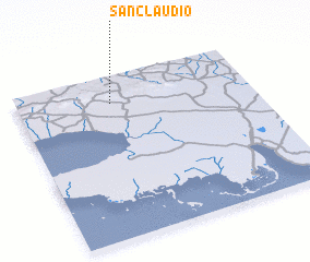 Places with similar names to San Claudio, Cuba ::
// Seinkalet (MM)
// San Claudio (ES)
// San Claudio (ES)
// San Clodio (ES)
// Sānglud (IN)
// Sangliat (ID)
// Senggelit (ID)
// Sungailaut (ID)
// Sungailiat (ID)
// Zhyngghyldy (KZ)
Disclaimer :: Information on this page comes without warranty of any kind |
||
|
Where is San Claudio? Elevation and coordinates ::
Latitude (lat): 22°50'3"N Longitude (lon): 81°35'49"W
Elevation (approx.): 77m (map arrows pan, magnifying glasses zoom) |
||
|
Visiting San Claudio? Hotel/Accommodation ::
Book a hotel in San Claudio Travel Guide ::
Buy a travel guide for Cuba rental cars ::
car rental offers GPS waypoint ::
download a GPX waypoint (PoI) of San Claudio for your GPS receiver
|
||