|
search place name
|
||
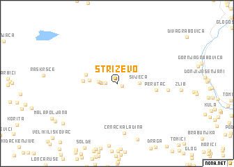
Striževo (Federacija Bosne i Hercegovine, Bosnia and Herzegovina)Striževo is a town in the Federacija Bosne i Hercegovine region of Bosnia and Herzegovina. An overview map of the region around Striževo is displayed below.
regional and 3d topo map of Striževo, Bosnia and Herzegovina ::
Striževo airports ::
The nearest airport is OMO - Mostar, located 34.9 km south east of Striževo.
Other airports nearby include SJJ - Sarajevo (67.0 km north east), SPU - Split (105.1 km west), DBV - Dubrovnik (121.7 km south east), TIV - Tivat (156.0 km south east), Nearby towns ::
Grubolaz (0.6km south east) //
Zagreblje (1.4km west) //
Bunčići (1.8km west) //
Gornja Drežnica (2.0km west) //
Poglavica (2.2km west) //
Svječa (2.6km east) //
Podužje (3.2km west) //
Rajići (3.9km west) //
Draga (4.0km west) //
Perutac (4.6km east) //
Crnačka Ladina (7.9km south) //
Kosirice (5.9km east) //
Bogodolska Ladina (9.2km south) //
Velika Poljana (9.0km south west) //
[all distances 'as the bird flies' and approximate]  Places with similar names to Striževo, Bosnia and Herzegovina ::
Disclaimer :: Information on this page comes without warranty of any kind |
||
|
Where is Striževo? Elevation and coordinates ::
Latitude (lat): 43°32'25"N Longitude (lon): 17°35'55"E
Elevation (approx.): 336m (map arrows pan, magnifying glasses zoom) |
||
|
Visiting Striževo? Hotel/Accommodation ::
Book a hotel in Striževo Travel Guide ::
rental cars ::
car rental offers GPS waypoint ::
download a GPX waypoint (PoI) of Striževo for your GPS receiver
|
||