|
search place name
|
||
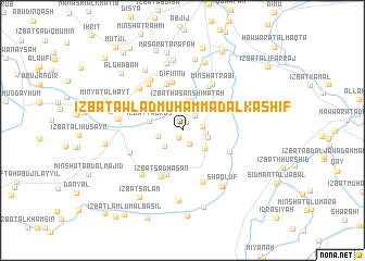
‘Izbat Awlād Muḩammad al Kāshif (Al Fayyūm, Egypt)‘Izbat Awlād Muḩammad al Kāshif is a town in the Al Fayyūm region of Egypt. An overview map of the region around ‘Izbat Awlād Muḩammad al Kāshif is displayed below.
regional and 3d topo map of ‘Izbat Awlād Muḩammad al Kāshif, Egypt ::
‘Izbat Awlād Muḩammad al Kāshif airports ::
The nearest airport is CAI - Cairo Intl, located 118.0 km north east of ‘Izbat Awlād Muḩammad al Kāshif.
Other airports nearby include ALY - Alexandria Intl (236.2 km north), Nearby towns ::
‘Izbat Ţulbah Bāshā (0.8km south west) //
Abū Diffīyah (0.9km north east) //
‘Izbat Anwar ‘Alī Şāliḩ (1.5km south east) //
‘Izbat Ramzī al Gharbīyah (1.8km north east) //
‘Izbat Muftāḩ Muḩammad ‘Aţā (1.9km east) //
‘Izbat Aḩmad Bāshā (2.1km east) //
As Sa‘dah (2.3km south west) //
‘Izbat as Sāyiḩ (2.3km west) //
‘Izbat Rizq Burayyik (2.4km east) //
‘Izbat Ḩasan Shiḩātah (2.9km north) //
‘Izbat Mihanná al Khūrī (2.7km south east) //
‘Izbat Ismā‘īlal Farīq (3.1km north) //
‘Izbat Tādrus (3.1km west) //
Qalamshāh (4.3km north east) //
‘Izbat Ḩamad al Bāsil (4.8km south) //
Kafr al ‘Ābid (4.9km north) //
Difinnū (5.1km north) //
‘Izbat Sa‘d Ḩasan (5.1km south) //
Qalhānah (5.1km north east) //
‘Izbat al Jabal (4.7km south east) //
Minshāt Rabī‘ (5.4km north east) //
Al Ḩamadīyah (5.6km south) //
‘Atāminat al Ja‘āfirah (5.6km north west) //
Kafr Ḩishmat (5.3km south west) //
Iţsā (5.9km north west) //
Al Ja‘āfirah (5.8km north west) //
Tuţūn (5.9km south west) //
‘Izbat aḑ Ḑaw (5.6km north west) //
Shidmūh (5.9km west) //
[all distances 'as the bird flies' and approximate]  Places with similar names to ‘Izbat Awlād Muḩammad al Kāshif, Egypt :: Disclaimer :: Information on this page comes without warranty of any kind |
||
|
Where is ‘Izbat Awlād Muḩammad al Kāshif? Elevation and coordinates ::
Latitude (lat): 29°11'27"N Longitude (lon): 30°48'54"E
Elevation (approx.): 15m (map arrows pan, magnifying glasses zoom) |
||
|
Visiting ‘Izbat Awlād Muḩammad al Kāshif? Hotel/Accommodation ::
Book a hotel in ‘Izbat Awlād Muḩammad al Kāshif Travel Guide ::
Buy a travel guide for Egypt rental cars ::
car rental offers GPS waypoint ::
download a GPX waypoint (PoI) of ‘Izbat Awlād Muḩammad al Kāshif for your GPS receiver
|
||