|
search place name
|
||
Kafr Ţanāḩ (Ad Daqahlīyah, Egypt)Kafr Ţanāḩ is a town in the Ad Daqahlīyah region of Egypt. An overview map of the region around Kafr Ţanāḩ is displayed below.
regional and 3d topo map of Kafr Ţanāḩ, Egypt ::

Kafr Ţanāḩ airports ::
The nearest airport is PSD - Port Said, located 71.2 km north east of Kafr Ţanāḩ.
Other airports nearby include CAI - Cairo Intl (102.0 km south), ALY - Alexandria Intl (153.6 km west), Nearby towns ::
Ṭanâḥ (0.5km north east) //
‘Izbat ‘Abd Allāh Ḩajar (0.6km south east) //
‘Izbat al Barbarī (1.9km south east) //
‘Izbat Maḩmūd ash Shinnāwī (2.0km north east) //
‘Izbat Karam al Gharbīyah (2.2km east) //
An Nasīmīyah (2.4km south east) //
‘Izbat Karam ash Sharqīyah (2.4km east) //
An Nāşirah (2.8km north west) //
Kawm Banī Mirās (2.8km south west) //
‘Izbat Muḩammad Tawfīq (3.1km south) //
Al Khalīj (2.9km west) //
‘Izbat Mīt Ḑāfir (3.6km north) //
Mît Maḥmûd (3.4km east) //
Al Khashāshinah (4.0km north east) //
Mīt Jarrāḩ (4.2km south) //
Mît `Azzûn (3.9km west) //
Al Mirsāh wa al Khashāshnah (5.2km north) //
Ash Shaykh Riḑwān (4.9km north west) //
‘Izbat ad Dawarānī (5.3km south) //
Mît Ḍâfir (5.5km north) //
Mīt Lawzah (5.5km south) //
‘Izbat Dibbānah (4.8km west) //
Al Mirsāh (5.4km north) //
Dimwah as Sibākh (5.8km north) //
Mît `Adlân (5.2km east) //
Mît Fâris (5.3km east) //
Al Qibāb aş Şughrá (6.3km north) //
Al Qibāb al Kubrá (6.4km north) //
Al Māliḩah (6.2km south west) //
[all distances 'as the bird flies' and approximate] 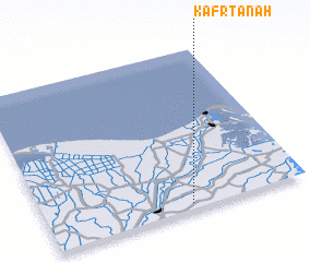 Places with similar names to Kafr Ţanāḩ, Egypt ::
// Kavardina (RU)
// Keifertown (US)
// Kavardan (UZ)
// Gowvārdān (IR)
// Gowvārdān (IR)
// Kovārdān (IR)
// Kafr at Tīn (SY)
// Kafr at Tūn (SY)
// Kafr Dannah (SY)
// Kafr Dīn (SY)
Disclaimer :: Information on this page comes without warranty of any kind |
||
|
Where is Kafr Ţanāḩ? Elevation and coordinates ::
Latitude (lat): 31°2'0"N Longitude (lon): 31°33'0"E
Elevation (approx.): 7m (map arrows pan, magnifying glasses zoom) |
||
|
Visiting Kafr Ţanāḩ? Hotel/Accommodation ::
Book a hotel in Kafr Ţanāḩ Travel Guide ::
Buy a travel guide for Egypt rental cars ::
car rental offers GPS waypoint ::
download a GPX waypoint (PoI) of Kafr Ţanāḩ for your GPS receiver
|
||