|
search place name
|
||
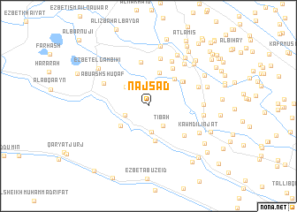
Naj‘ Sa‘d (Al Buḩayrah, Egypt)Naj‘ Sa‘d is a town in the Al Buḩayrah region of Egypt. An overview map of the region around Naj‘ Sa‘d is displayed below.
regional and 3d topo map of Naj‘ Sa‘d, Egypt ::
Naj‘ Sa‘d airports ::
The nearest airport is ALY - Alexandria Intl, located 61.0 km north west of Naj‘ Sa‘d.
Other airports nearby include CAI - Cairo Intl (121.8 km south east), PSD - Port Said (175.9 km east), Nearby towns ::
Al Khalīlīyah (2.6km north) //
Ţībah (2.9km south east) //
Zāwiyat Ḩammūr (2.8km south west) //
Ţaybah (3.3km south) //
Al ‘Allāmīyah (3.5km north east) //
`Ezbet `Elwâni (3.4km north west) //
Naj‘ Mata‘āţīsh (4.0km south west) //
Naj‘ al ‘Aţfī (4.4km north) //
Qamḩah (4.5km south) //
Al Ḩajar al Maḩrūq (4.4km north east) //
Ruzzāfah (4.7km north east) //
Al Ḩajar al Maḩrūq (4.9km north east) //
Al Ḩajar al Maḩrūq (4.9km north east) //
`Ezbet el-Tâ`ib Gâli (5.6km north) //
Naj‘ al Gharbāwī (5.4km north east) //
‘Izbat Waḩīdah Abū Ismā‘īl (5.4km south east) //
Naj‘ ad Dūktūr (6.1km north) //
Naj‘ Bīr al ‘Asal (6.1km north east) //
Abū ash Shuqāf (5.6km north west) //
‘Izbat Mitwallī Abū Zayd (5.9km north east) //
‘Izbat Farghalī (6.6km north east) //
Abū Si‘ayfah (6.0km east) //
Abū Su‘ayfah (6.0km east) //
‘Izbat Fahmī (6.1km east) //
Kawm Dilinjāt (6.5km south east) //
Naj‘ Rashīd Mihannā (7.2km north east) //
Naj‘ Muḩammad Fāḑīl (7.6km north) //
‘Izbat al ‘Awwāmah al Gharbīyah (7.3km north east) //
‘Izbat Bābādublū (6.8km east) //
[all distances 'as the bird flies' and approximate]  Places with similar names to Naj‘ Sa‘d, Egypt ::
// Naujasodė (LT)
// Negeşti (RO)
// Negeşti (RO)
// Negeşti (RO)
// Naj‘ aş Şa‘āydah (EG)
// Naj‘ Sa‘d (EG)
// Naj‘ Sa‘īd (EG)
// Naj‘ Siţayḩ (EG)
// Gnojište (CS)
Disclaimer :: Information on this page comes without warranty of any kind |
||
|
Where is Naj‘ Sa‘d? Elevation and coordinates ::
Latitude (lat): 30°51'27"N Longitude (lon): 30°27'47"E
Elevation (approx.): 3m (map arrows pan, magnifying glasses zoom) |
||
|
Visiting Naj‘ Sa‘d? Hotel/Accommodation ::
Book a hotel in Naj‘ Sa‘d Travel Guide ::
Buy a travel guide for Egypt rental cars ::
car rental offers GPS waypoint ::
download a GPX waypoint (PoI) of Naj‘ Sa‘d for your GPS receiver
|
||