|
search place name
|
||
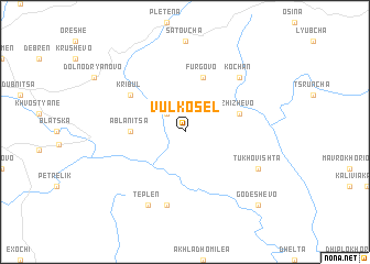
Vŭlkosel (Bulgaria)Vŭlkosel is a town in Bulgaria. An overview map of the region around Vŭlkosel is displayed below.
regional and 3d topo map of Vŭlkosel, Bulgaria ::
Vŭlkosel airports ::
The nearest airport is KVA - Kavala Megas Alexandros Intl, located 87.1 km south east of Vŭlkosel.
Other airports nearby include PDV - Plovdiv (93.4 km north east), SOF - Sofia (137.6 km north), SKG - Thessaloniki Makedonia (141.1 km south west), AXD - Alexandroupolis Dimokritos (181.8 km south east), Nearby towns ::
Bogolin (2.3km north west) //
Ablanitsa (4.2km west) //
Zhizhevo (4.6km north east) //
Fŭrgovo (5.7km north) //
Kribul (5.6km north west) //
Beslen (7.5km south) //
Kochan (6.9km north east) //
Teplen (7.9km south) //
Tukhovishta (6.7km south east) //
Godeshevo (9.3km south east) //
[all distances 'as the bird flies' and approximate]  Places with similar names to Vŭlkosel, Bulgaria ::
// Vilksala (LV)
// Valea Căşeiului (RO)
// Villouxel (FR)
// (( Veliko Selo )) (BA)
// Velʼke Selo (BY)
// Velʼke Sëlo (BY)
// Flaxley (AU)
// Volgsele (SE)
// Viluksela (FI)
// Flaxley (GB)
Disclaimer :: Information on this page comes without warranty of any kind |
||
|
Where is Vŭlkosel? Elevation and coordinates ::
Latitude (lat): 41°32'0"N Longitude (lon): 23°59'0"E
Elevation (approx.): 841m (map arrows pan, magnifying glasses zoom) |
||
|
Visiting Vŭlkosel? Hotel/Accommodation ::
Book a hotel in Vŭlkosel Travel Guide ::
Buy a travel guide for Bulgaria rental cars ::
car rental offers GPS waypoint ::
download a GPX waypoint (PoI) of Vŭlkosel for your GPS receiver
|
||