|
search place name
|
||
Gumbalnieki (Ventspils Rajons, Latvia)Gumbalnieki is a town in the Ventspils Rajons region of Latvia. An overview map of the region around Gumbalnieki is displayed below.
regional and 3d topo map of Gumbalnieki, Latvia ::
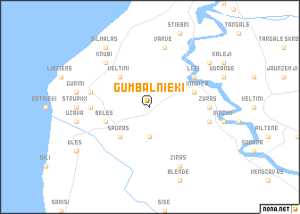
Nearby towns ::
Dzirtnieki (3.7km south) //
Spuras (4.2km south west) //
Veltiņi (4.2km north west) //
Beles (3.5km south west) //
Jaunmuiža (3.5km north east) //
Lēči (4.8km north east) //
Stoki (4.0km west) //
Zūras (4.0km east) //
Brunči (4.4km north west) //
Vārve (7.5km north) //
Annasmuiža (4.4km south east) //
Knubi (6.3km north west) //
Ziras (7.7km south) //
Silmalas (8.0km north) //
Abelnieki (6.9km north east) //
[all distances 'as the bird flies' and approximate] 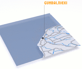 Places with similar names to Gumbalnieki, Latvia ::
// Camaliñgao (PH)
// Cambaling (PH)
// Camiling (PH)
// Camiling (PH)
// Camiling (PH)
// Guiamlong (PH)
// Gamling (AT)
// Kaimling (DE)
// Komlenac (BA)
// KuMbulunga (ZA)
Disclaimer :: Information on this page comes without warranty of any kind |
||
|
Where is Gumbalnieki? Elevation and coordinates ::
Latitude (lat): 57°15'0"N Longitude (lon): 21°32'0"E
Elevation (approx.): 9m (map arrows pan, magnifying glasses zoom) |
||
|
Visiting Gumbalnieki? Hotel/Accommodation ::
Book a hotel in Gumbalnieki Travel Guide ::
Buy a travel guide for Latvia rental cars ::
car rental offers GPS waypoint ::
download a GPX waypoint (PoI) of Gumbalnieki for your GPS receiver
|
||