|
search place name
|
||
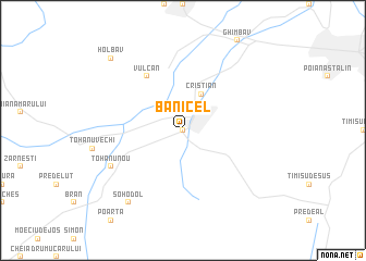
Bănicel (Covurlui, Romania)Bănicel is a town in the Covurlui region of Romania. An overview map of the region around Bănicel is displayed below.
regional and 3d topo map of Bănicel, Romania ::
Bănicel airports ::
The nearest airport is SBZ - Sibiu, located 108.2 km west of Bănicel.
Other airports nearby include OTP - Bucharest Henri Coanda (123.6 km south east), TGM - Tirgu Mures Vidrasau (126.9 km north west), BBU - Bucharest Aurel Vlaicu (130.6 km south east), BCM - Bacau (153.8 km north east), Nearby towns ::
Rîşnov (0.0km north) //
Cristian (3.9km north) //
Vulcan (6.1km north west) //
Colonia Întăi Mai (6.1km north west) //
Tohanu Nou (6.4km south west) //
Sohodol (8.4km south west) //
Holbav (9.0km north west) //
[all distances 'as the bird flies' and approximate]  Places with similar names to Bănicel, Romania ::
// Bounezzal (MA)
// Bansal (PH)
// Banzal (PH)
// Benzal (US)
// Bonsall (US)
// Bonzel (DE)
// Bonsal (DE)
// Banzola (IT)
// Banī Şāliḩ (IQ)
// Banī Şāliḩ (IQ)
Disclaimer :: Information on this page comes without warranty of any kind |
||
|
Where is Bănicel? Elevation and coordinates ::
Latitude (lat): 45°35'0"N Longitude (lon): 25°27'0"E
Elevation (approx.): 642m (map arrows pan, magnifying glasses zoom) |
||
|
Visiting Bănicel? Hotel/Accommodation ::
Book a hotel in Bănicel Travel Guide ::
Buy a travel guide for Romania rental cars ::
car rental offers GPS waypoint ::
download a GPX waypoint (PoI) of Bănicel for your GPS receiver
|
||