|
search place name
|
||
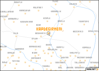
Kapdeğirmeni (Kilis, Turkey)Kapdeğirmeni is a town in the Kilis region of Turkey. An overview map of the region around Kapdeğirmeni is displayed below.
regional and 3d topo map of Kapdeğirmeni, Turkey ::
Kapdeğirmeni airports ::
The nearest airport is GZT - Gaziantep Oguzeli, located 33.7 km north east of Kapdeğirmeni.
Other airports nearby include ALP - Aleppo Intl (59.7 km south), ADA - Adana Incirlik Ab (163.9 km west), ADA - Adana (176.2 km west), LTK - Latakia Bassel Al Assad Intl (186.2 km south west), Nearby towns ::
Yananköy (0.4km south east) //
Beşikkaya (2.7km west) //
Akıncı (4.7km south) //
Acar (4.3km north west) //
Ceritler (4.4km north east) //
Uzunlu (5.5km north) //
Oylum (4.9km south west) //
Arbah Kasmāz (6.1km south) //
Oruçlu (5.7km north east) //
Ḩarjalah (6.5km south) //
Ḩiwār Kalas (6.7km south) //
Ḩawār Killis (6.8km south) //
Hümeyli (6.5km south east) //
Arpakesmez (6.8km south west) //
Dalḩah (7.8km south) //
Aykadah (8.0km south west) //
Karamelik (8.3km north) //
Qarah Mazra‘ah (8.3km south east) //
Īkdah (8.8km south west) //
Kuskunkıran (8.0km north west) //
Bghīdīn (9.9km south east) //
[all distances 'as the bird flies' and approximate]  Places with similar names to Kapdeğirmeni, Turkey :: Disclaimer :: Information on this page comes without warranty of any kind |
||
|
Where is Kapdeğirmeni? Elevation and coordinates ::
Latitude (lat): 36°43'7"N Longitude (lon): 37°13'45"E
Elevation (approx.): 558m (map arrows pan, magnifying glasses zoom) |
||
|
Visiting Kapdeğirmeni? Hotel/Accommodation ::
Book a hotel in Kapdeğirmeni Travel Guide ::
Buy a travel guide for Turkey rental cars ::
car rental offers GPS waypoint ::
download a GPX waypoint (PoI) of Kapdeğirmeni for your GPS receiver
|
||