|
search place name
|
||
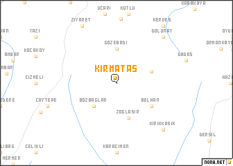
Kırmataş (Diyarbakır, Turkey)Kırmataş is a town in the Diyarbakır region of Turkey. An overview map of the region around Kırmataş is displayed below.
regional and 3d topo map of Kırmataş, Turkey ::
Kırmataş airports ::
The nearest airport is DIY - Diyabakir Diyarbakir, located 53.8 km south west of Kırmataş.
Other airports nearby include BAL - Batman (56.5 km south east), EZS - Elazig (122.3 km west), ERC - Erzincan (187.6 km north west), ERZ - Erzurum (195.4 km north), Nearby towns ::
Bozbağlar (4.7km south west) //
Gözebaşı (5.6km north) //
Zoğlasır (5.7km south) //
Kavaklıboğaz (4.7km north east) //
Belhan (5.7km south east) //
Kırıkkaşık (9.4km south east) //
Dolunay (9.4km north east) //
[all distances 'as the bird flies' and approximate] 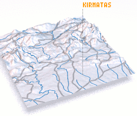 Places with similar names to Kırmataş, Turkey ::
// Cremitz (DE)
// Görmitz (DE)
// Grömitz (DE)
// Karmitz (DE)
// Kremitz (DE)
// Kuremetsa (EE)
// Karamatići (BA)
// Karamatići (BA)
// Khromitsa (BG)
// Kiremitçi (TR)
Disclaimer :: Information on this page comes without warranty of any kind |
||
|
Where is Kırmataş? Elevation and coordinates ::
Latitude (lat): 38°15'0"N Longitude (lon): 40°37'0"E
Elevation (approx.): 882m (map arrows pan, magnifying glasses zoom) |
||
|
Visiting Kırmataş? Hotel/Accommodation ::
Book a hotel in Kırmataş Travel Guide ::
Buy a travel guide for Turkey rental cars ::
car rental offers GPS waypoint ::
download a GPX waypoint (PoI) of Kırmataş for your GPS receiver
|
||