|
search place name
|
||
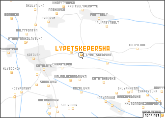
(( Lypets'ke Persha )) (Odesʼka Oblastʼ, Ukraine)(( Lypets'ke Persha )) is a town in the Odesʼka Oblastʼ region of Ukraine. An overview map of the region around (( Lypets'ke Persha )) is displayed below.
regional and 3d topo map of (( Lypets'ke Persha )), Ukraine ::
(( Lypets'ke Persha )) airports ::
The nearest airport is KIV - Kichinau Fir/acc/com Chisinau Intl, located 105.7 km south west of (( Lypets'ke Persha )).
Other airports nearby include ODS - Odessa Odesa Intl (167.1 km south east), Nearby towns ::
Oleksandrivka (2.3km north west) //
(( Lypets'ke Druhe )) (2.5km east) //
Andriyivka (4.8km south) //
Chapayevka (3.8km south west) //
Mala Oleksandrivka (5.2km south) //
Lypets'ke (3.9km east) //
Kuybyshevs'ke (6.2km south east) //
Rozalivka (7.6km south) //
Kuyal'nyk (6.4km west) //
(( Mali Pasytsely )) (8.3km north east) //
Sobolivka (8.0km south west) //
Hrekove Pershe (9.3km south east) //
Hyderym (9.9km north west) //
[all distances 'as the bird flies' and approximate]  Places with similar names to (( Lypets'ke Persha )), Ukraine :: Disclaimer :: Information on this page comes without warranty of any kind |
||
|
Where is (( Lypets'ke Persha ))? Elevation and coordinates ::
Latitude (lat): 47°45'0"N Longitude (lon): 29°38'0"E
Elevation (approx.): 146m (map arrows pan, magnifying glasses zoom) |
||
|
Visiting (( Lypets'ke Persha ))? Hotel/Accommodation ::
Book a hotel in (( Lypets'ke Persha )) Travel Guide ::
Buy a travel guide for Ukraine rental cars ::
car rental offers GPS waypoint ::
download a GPX waypoint (PoI) of (( Lypets'ke Persha )) for your GPS receiver
|
||