|
search place name
|
||
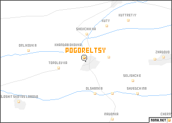
Pogorelʼtsy (Chernihivsʼka Oblastʼ, Ukraine)Pogorelʼtsy is a town in the Chernihivsʼka Oblastʼ region of Ukraine. An overview map of the region around Pogorelʼtsy is displayed below.
regional and 3d topo map of Pogorelʼtsy, Ukraine ::
Pogorelʼtsy airports ::
The nearest airport is GME - Gomel, located 115.4 km north west of Pogorelʼtsy.
Other airports nearby include BZK - Bryansk (171.9 km north east), KBP - Kiev Boryspil Intl (220.5 km south west), Nearby towns ::
Khandabokovka (3.4km north west) //
Losevka (3.2km east) //
Shevchikha (6.0km north) //
Topolëvka (4.0km west) //
Olʼshanka (7.1km south) //
Kuty (8.2km north) //
Staraya Gutka (7.8km south east) //
[all distances 'as the bird flies' and approximate] 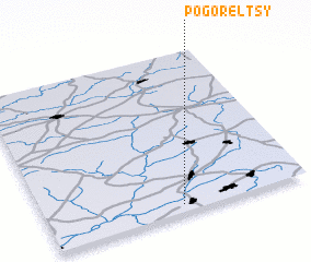 Places with similar names to Pogorelʼtsy, Ukraine ::
// Pogorelitsa (RU)
// Pogorelʼtsy (UA)
// Pogorelʼtsy (UA)
// Pogorelʼtsy (UA)
// Pogorel'tsy (RU)
// Pogorelʼtsy (BY)
// Pogorelʼtsy (BY)
// Pogorelʼtsy (BY)
// Pogorelets (RU)
// Pogorelets (RU)
Disclaimer :: Information on this page comes without warranty of any kind |
||
|
Where is Pogorelʼtsy? Elevation and coordinates ::
Latitude (lat): 52°2'45"N Longitude (lon): 32°30'55"E
Elevation (approx.): 170m (map arrows pan, magnifying glasses zoom) |
||
|
Visiting Pogorelʼtsy? Hotel/Accommodation ::
Book a hotel in Pogorelʼtsy Travel Guide ::
Buy a travel guide for Ukraine rental cars ::
car rental offers GPS waypoint ::
download a GPX waypoint (PoI) of Pogorelʼtsy for your GPS receiver
|
||