|
search place name
|
||
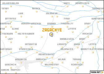
Zagachʼye (Ukraine)Zagachʼye is a town in Ukraine. An overview map of the region around Zagachʼye is displayed below.
regional and 3d topo map of Zagachʼye, Ukraine ::
Zagachʼye airports ::
The nearest airport is LWO - Lvov Lviv Intl, located 49.4 km north east of Zagachʼye.
Other airports nearby include RZE - Rzeszow Jasionka (136.5 km north west), BAY - Baia Mare Tautii Magheraus (197.6 km south), SUJ - Satu Mare (199.5 km south), DEB - Debrecen (261.3 km south west), Nearby towns ::
Rolev (2.2km north east) //
Dobrovlyany (2.4km west) //
Grushev (3.7km north) //
Lipovets (4.4km south east) //
Voroblevichi (4.1km south east) //
Tynuv Malyy (5.2km north east) //
Mikhaylovichi (7.4km south) //
Voloshcha (7.4km north) //
Pochaykovitsy (7.5km south) //
Rozvadov (7.5km north) //
Litynya (5.2km east) //
Tynuv (6.6km north east) //
Solonskoye (6.6km south east) //
Rykhtichi (6.6km south west) //
Vatsovitse (6.1km south west) //
Verkhniy Dorozhev (6.1km north west) //
[all distances 'as the bird flies' and approximate] 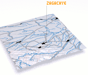 Places with similar names to Zagachʼye, Ukraine ::
// Zakoch'ye (RU)
Disclaimer :: Information on this page comes without warranty of any kind |
||
|
Where is Zagachʼye? Elevation and coordinates ::
Latitude (lat): 49°26'0"N Longitude (lon): 23°36'0"E
Elevation (approx.): 280m (map arrows pan, magnifying glasses zoom) |
||
|
Visiting Zagachʼye? Hotel/Accommodation ::
Book a hotel in Zagachʼye Travel Guide ::
Buy a travel guide for Ukraine rental cars ::
car rental offers GPS waypoint ::
download a GPX waypoint (PoI) of Zagachʼye for your GPS receiver
|
||