|
search place name
|
||
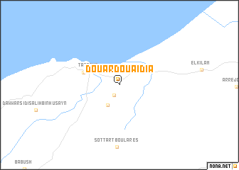
Douar Douaïdia (Jendouba, Tunisia)Douar Douaïdia is a town in the Jendouba region of Tunisia. An overview map of the region around Douar Douaïdia is displayed below.
regional and 3d topo map of Douar Douaïdia, Tunisia ::
Douar Douaïdia airports ::
The nearest airport is AAE - Annaba, located 89.3 km west of Douar Douaïdia.
Other airports nearby include TUN - Tunis Carthage (127.5 km east), TEE - Tebessa Cheikh Larbi Tebessi (177.7 km south), MIR - Monastir Habib Bourguiba Intl (218.7 km south east), Nearby towns ::
Douar Sidi Amor (1.7km south west) //
Ksour Lireba (3.5km south west) //
Tabarka (4.4km north west) //
Douar Kabyle (4.9km north west) //
[all distances 'as the bird flies' and approximate]  Places with similar names to Douar Douaïdia, Tunisia ::
// Tuora-Tiit (RU)
// Tourtit (MA)
// Torredeita (PT)
// Trædet (NO)
// Dar Titi (TN)
// Douar Douaouda (TN)
// Tardad (ES)
// Dār-e Tūt (IR)
// Dār Tūt (IR)
// Dār Tūt (IR)
Disclaimer :: Information on this page comes without warranty of any kind |
||
|
Where is Douar Douaïdia? Elevation and coordinates ::
Latitude (lat): 36°56'8"N Longitude (lon): 8°48'4"E
Elevation (approx.): 57m (map arrows pan, magnifying glasses zoom) |
||
|
Visiting Douar Douaïdia? Hotel/Accommodation ::
Book a hotel in Douar Douaïdia Travel Guide ::
Buy a travel guide for Tunisia rental cars ::
car rental offers GPS waypoint ::
download a GPX waypoint (PoI) of Douar Douaïdia for your GPS receiver
|
||