|
search place name
|
||
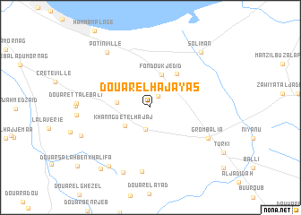
Douar el Haj Ayas (Nabeul, Tunisia)Douar el Haj Ayas is a town in the Nabeul region of Tunisia. An overview map of the region around Douar el Haj Ayas is displayed below.
regional and 3d topo map of Douar el Haj Ayas, Tunisia ::
Douar el Haj Ayas airports ::
The nearest airport is TUN - Tunis Carthage, located 30.4 km north west of Douar el Haj Ayas.
Other airports nearby include MIR - Monastir Habib Bourguiba Intl (101.4 km south), PNL - Pantelleria (138.5 km east), SFA - Sfax Thyna (213.9 km south), Nearby towns ::
Camp Servière (1.5km north east) //
Douar Mannoubi (2.7km south) //
Khannguet el Hajaj (3.4km south west) //
Douar el Haj Mohammed (3.5km west) //
Fondouk Jedid (4.2km north) //
Douar Mesratia (4.9km north east) //
Douar el Haj Toumi (8.0km south) //
Grombalia (7.0km south east) //
Potinville (8.1km north west) //
Douar el Haj Mannsour (8.6km south) //
Douar Oulad ech Cherabi (8.4km south west) //
Douar Ben Saïd (7.8km south west) //
Soliman (8.6km north east) //
Douar el Jedid (9.1km south west) //
[all distances 'as the bird flies' and approximate]  Places with similar names to Douar el Haj Ayas, Tunisia :: Disclaimer :: Information on this page comes without warranty of any kind |
||
|
Where is Douar el Haj Ayas? Elevation and coordinates ::
Latitude (lat): 36°38'3"N Longitude (lon): 10°26'5"E
Elevation (approx.): 113m (map arrows pan, magnifying glasses zoom) |
||
|
Visiting Douar el Haj Ayas? Hotel/Accommodation ::
Book a hotel in Douar el Haj Ayas Travel Guide ::
Buy a travel guide for Tunisia rental cars ::
car rental offers GPS waypoint ::
download a GPX waypoint (PoI) of Douar el Haj Ayas for your GPS receiver
|
||