|
search place name
|
||
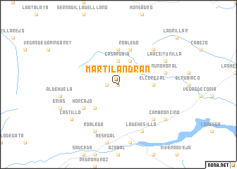
Martilandrán (Extremadura, Spain)Martilandrán is a town in the Extremadura region of Spain. An overview map of the region around Martilandrán is displayed below.
regional and 3d topo map of Martilandrán, Spain ::
Martilandrán airports ::
The nearest airport is SLM - Salamanca, located 91.2 km north east of Martilandrán.
Other airports nearby include VRL - Vila Real (154.2 km north west), BGC - Braganca (165.5 km north), BJZ - Badajoz Talavera La Real (173.4 km south), VLL - Valladolid (189.4 km north east), Nearby towns ::
Fragosa (0.0km north) //
El Gasco (1.4km west) //
Casa Rubia (3.7km north) //
El Asegur (3.4km north east) //
Casares de las Hurdes (4.0km north) //
Avellanar (4.7km south west) //
El Cerezal (4.2km east) //
Huetre (5.6km north) //
Robledo (5.7km north) //
Carabusino (5.7km north) //
Horcajo (5.6km south west) //
Nuñomoral (5.9km east) //
Cambrón (7.0km south east) //
Ríomalo de Arriba (7.0km north east) //
La Dehesilla (7.9km south) //
Robledo (7.9km south) //
Huerta (7.9km south) //
La Aceitunilla (6.8km north east) //
Castillo (7.9km south west) //
Cambroncino (7.9km south east) //
[all distances 'as the bird flies' and approximate] 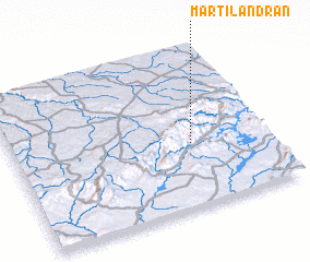 Places with similar names to Martilandrán, Spain :: Disclaimer :: Information on this page comes without warranty of any kind |
||
|
Where is Martilandrán? Elevation and coordinates ::
Latitude (lat): 40°24'0"N Longitude (lon): 6°18'0"W
Elevation (approx.): 792m (map arrows pan, magnifying glasses zoom) |
||
|
Visiting Martilandrán? Hotel/Accommodation ::
Book a hotel in Martilandrán Travel Guide ::
Buy a travel guide for Spain rental cars ::
car rental offers GPS waypoint ::
download a GPX waypoint (PoI) of Martilandrán for your GPS receiver
|
||