|
search place name
|
||
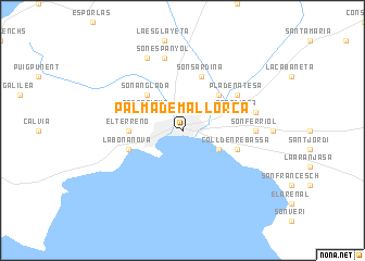
Palma de Mallorca (Islas Baleares, Spain)Palma de Mallorca is a town in the Islas Baleares region of Spain. An overview map of the region around Palma de Mallorca is displayed below.
regional and 3d topo map of Palma de Mallorca, Spain ::
Palma de Mallorca airports ::
The nearest airport is PMI - Palma De Mallorca (Son San Juan), located 7.8 km east of Palma de Mallorca.
Other airports nearby include IBZ - Ibiza (134.5 km south west), MAH - Menorca (138.5 km east), BCN - Barcelona (198.2 km north), REU - Reus (216.0 km north west), Nearby towns ::
Son Rapinya (3.4km north west) //
Molinar de Levante (3.4km south east) //
Son Anglada (4.7km north west) //
Indiotería (4.7km north east) //
El Terreno (4.3km west) //
Pont dʼInca (4.7km north east) //
La Bonanova (4.7km south west) //
Coll dʼen Rebassa (4.7km south east) //
Son Sardina (5.7km north) //
Pla de na Tesa (5.7km north east) //
Son Ferriol (5.7km east) //
Son Espanyol (7.5km north) //
Creu Vermella (6.0km east) //
Establiments (7.9km north) //
[all distances 'as the bird flies' and approximate] 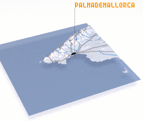 Places with similar names to Palma de Mallorca, Spain :: Disclaimer :: Information on this page comes without warranty of any kind |
||
|
Where is Palma de Mallorca? Elevation and coordinates ::
Latitude (lat): 39°34'0"N Longitude (lon): 2°39'0"E
Elevation (approx.): 18m (map arrows pan, magnifying glasses zoom) |
||
|
Visiting Palma de Mallorca? Hotel/Accommodation ::
Book a hotel in Palma de Mallorca Travel Guide ::
Buy a travel guide for Spain rental cars ::
car rental offers GPS waypoint ::
download a GPX waypoint (PoI) of Palma de Mallorca for your GPS receiver
|
||