|
search place name
|
||
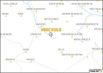
Pancrudo (Aragón, Spain)Pancrudo is a town in the Aragón region of Spain. An overview map of the region around Pancrudo is displayed below.
regional and 3d topo map of Pancrudo, Spain ::
Pancrudo airports ::
The nearest airport is ZAZ - Zaragoza Ab, located 99.9 km north of Pancrudo.
Other airports nearby include VLC - Valencia (149.4 km south), Nearby towns ::
Alpeñés (4.6km north west) //
Portalrubio (5.6km north) //
Corbatón (4.2km west) //
Rillo (6.2km south east) //
Cervera del Rincón (5.6km east) //
Cuevas de Portalrubio (7.0km north east) //
La Rambla de Martín (9.3km north east) //
Fuentes Calientes (9.3km south east) //
[all distances 'as the bird flies' and approximate]  Places with similar names to Pancrudo, Spain ::
// Pinckard (US)
// Pino Gordo (CU)
// Pîngăraţi (RO)
// Pinckard (US)
// Piney Court (US)
// Pino Gordo (GT)
// Pancurido (ID)
// Pino Gordo (MX)
// Pino Gordo (MX)
// Piane Crati (IT)
Disclaimer :: Information on this page comes without warranty of any kind |
||
|
Where is Pancrudo? Elevation and coordinates ::
Latitude (lat): 40°46'0"N Longitude (lon): 1°2'0"W
Elevation (approx.): 1252m (map arrows pan, magnifying glasses zoom) |
||
|
Visiting Pancrudo? Hotel/Accommodation ::
Book a hotel in Pancrudo Travel Guide ::
Buy a travel guide for Spain rental cars ::
car rental offers GPS waypoint ::
download a GPX waypoint (PoI) of Pancrudo for your GPS receiver
|
||