|
search place name
|
||
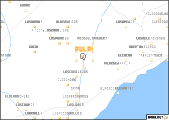
Pulpí (Andalucía, Spain)Pulpí is a town in the Andalucía region of Spain. An overview map of the region around Pulpí is displayed below.
regional and 3d topo map of Pulpí, Spain ::
Pulpí airports ::
The nearest airport is LEI - Almeria, located 82.7 km south west of Pulpí.
Other airports nearby include MJV - Murcia San Javier (92.7 km north east), ALC - Alicante (143.5 km north east), GRX - Granada Armilla (169.9 km west), ORN - Oran Es Senia (221.5 km south east), Nearby towns ::
Las Casicas (1.5km east) //
El Convoy (1.5km west) //
Casas Altas (1.9km south) //
La Fuente (1.9km south) //
El Molino (2.4km north east) //
Benzal (2.4km north west) //
Las Canalejas (4.0km south) //
Pozo de la Higuera (4.0km north) //
Los Soleres (4.7km north west) //
Guazamara (6.3km south west) //
Los Pinares (5.8km north west) //
Grima (7.6km south) //
Los Caparroses (6.2km east) //
Pilar de Jaravía (6.2km east) //
Almendricos (8.0km north) //
Rincón y las Ramblicas (8.1km north west) //
El Pozo del Esparto (9.5km south east) //
[all distances 'as the bird flies' and approximate] 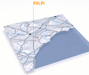 Places with similar names to Pulpí, Spain ::
Disclaimer :: Information on this page comes without warranty of any kind |
||
|
Where is Pulpí? Elevation and coordinates ::
Latitude (lat): 37°24'0"N Longitude (lon): 1°45'0"W
Elevation (approx.): 185m (map arrows pan, magnifying glasses zoom) |
||
|
Visiting Pulpí? Hotel/Accommodation ::
Book a hotel in Pulpí Travel Guide ::
Buy a travel guide for Spain rental cars ::
car rental offers GPS waypoint ::
download a GPX waypoint (PoI) of Pulpí for your GPS receiver
|
||