|
search place name
|
||
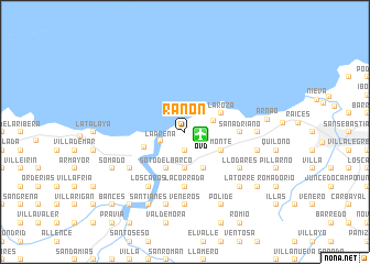
Ranón (Asturias, Spain)Ranón is a town in the Asturias region of Spain. An overview map of the region around Ranón is displayed below.
regional and 3d topo map of Ranón, Spain ::
Ranón airports ::
The nearest airport is OVD - Aviles Asturias, located 1.3 km east of Ranón.
Other airports nearby include BGC - Braganca (197.3 km south), VLL - Valladolid (228.8 km south east), Nearby towns ::
Navalón (1.3km east) //
Carbajal (1.9km south) //
La Arena (2.0km south west) //
Bayas (2.4km north east) //
Ponte (3.7km south) //
Caseras (3.7km south) //
Foncubierta (3.7km south) //
La Roza (3.3km north east) //
Monte (3.3km south east) //
La Ferrería (3.9km south) //
Folgueras (3.9km south) //
Soto del Barco (3.9km south) //
San Esteban de Pravia (3.4km south west) //
La Corrada (5.6km south) //
Naveces (4.0km east) //
San Adriano (4.0km east) //
Mar (4.0km east) //
Los Cabos (6.2km south west) //
Muros de Nalón (5.5km south west) //
La Ramera (5.5km south east) //
Llodares (5.5km south east) //
Veneros (7.4km south) //
Laspra (5.4km east) //
Monterrey (7.5km south) //
Riberas (7.5km south) //
La Braña (5.7km east) //
Las Bárzanas (5.7km east) //
La Torre (6.9km south east) //
Polide (7.9km south) //
[all distances 'as the bird flies' and approximate]  Places with similar names to Ranón, Spain ::
Disclaimer :: Information on this page comes without warranty of any kind |
||
|
Where is Ranón? Elevation and coordinates ::
Latitude (lat): 43°34'0"N Longitude (lon): 6°3'0"W
Elevation (approx.): 103m (map arrows pan, magnifying glasses zoom) |
||
|
Visiting Ranón? Hotel/Accommodation ::
Book a hotel in Ranón Travel Guide ::
Buy a travel guide for Spain rental cars ::
car rental offers GPS waypoint ::
download a GPX waypoint (PoI) of Ranón for your GPS receiver
|
||