|
search place name
|
||
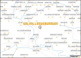
Salinillas de Buradón (País Vasco, Spain)Salinillas de Buradón is a town in the País Vasco region of Spain. An overview map of the region around Salinillas de Buradón is displayed below.
regional and 3d topo map of Salinillas de Buradón, Spain ::
Salinillas de Buradón airports ::
The nearest airport is VIT - Vitoria, located 28.7 km north of Salinillas de Buradón.
Other airports nearby include BIO - Bilbao (74.6 km north), PNA - Pamplona (97.1 km east), EAS - San Sebastian (116.0 km north east), SDR - Santander (120.3 km north west), Nearby towns ::
Ocio (1.9km north) //
Berganzo (2.3km north east) //
Briñas (3.9km south) //
Santa Cruz del Fierro (3.3km north west) //
Portilla (3.9km north) //
Haro (6.2km south west) //
Berantevilla (6.2km north west) //
Labastida (6.2km south east) //
Zambrana (5.5km north west) //
Tobera (6.2km north east) //
Santurde (6.2km north east) //
Mijancas (7.4km north) //
Villalba de Rioja (5.8km west) //
Villanueva Tobera (6.9km north east) //
Ribas de Tereso (6.6km south east) //
San Vicente de la Sonsierra (9.2km south east) //
Ribaguda (9.2km north west) //
[all distances 'as the bird flies' and approximate]  Places with similar names to Salinillas de Buradón, Spain :: Disclaimer :: Information on this page comes without warranty of any kind |
||
|
Where is Salinillas de Buradón? Elevation and coordinates ::
Latitude (lat): 42°38'0"N Longitude (lon): 2°49'0"W
Elevation (approx.): 604m (map arrows pan, magnifying glasses zoom) |
||
|
Visiting Salinillas de Buradón? Hotel/Accommodation ::
Book a hotel in Salinillas de Buradón Travel Guide ::
Buy a travel guide for Spain rental cars ::
car rental offers GPS waypoint ::
download a GPX waypoint (PoI) of Salinillas de Buradón for your GPS receiver
|
||