|
search place name
|
||
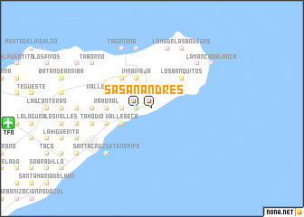
San Andrés (Canarias, Spain)San Andrés is a town in the Canarias region of Spain. An overview map of the region around San Andrés is displayed below.
regional and 3d topo map of San Andrés, Spain ::
San Andrés airports ::
The nearest airport is TFN - Tenerife Norte, located 15.6 km west of San Andrés.
Other airports nearby include TFS - Tenerife Sur (63.3 km south west), LPA - Gran Canaria (100.4 km south east), SPC - Santa Cruz De La Palma La Palma (154.5 km west), VDE - Hierro (183.8 km south west), Nearby towns ::
San Andrés (1.6km west) //
Valle de Jaqua (1.6km west) //
El Mesón (1.9km north) //
El Roque (1.6km west) //
Salazones (1.6km west) //
Muñoz (1.9km north) //
La Montañita (1.9km north) //
Cueva Bermeja (3.3km west) //
Los Pasitos (3.3km west) //
Viña Vieja (4.0km north west) //
Los Tableros (4.0km north west) //
Igueste (3.7km north east) //
Casas de Abajo (3.7km north east) //
El Mantillo (3.7km north east) //
Lomito del Llano (3.7km north east) //
Valle Seco (3.7km south west) //
La Mancha de los Cardos (3.7km north west) //
Las Canteras (3.7km north west) //
Lomo de las Canteras (3.7km north west) //
Los Banquitos (4.9km north east) //
Lomo de la Cruz (4.9km north east) //
Lomo Bermejo (4.9km north east) //
Roque Negro (4.9km north west) //
María Jiménez (4.9km west) //
Ramonal (4.9km west) //
Lomo de los Berros (5.2km west) //
Barrio de la Alegría (5.2km west) //
Boca del Valle (5.2km west) //
Valle Brosque (5.2km west) //
[all distances 'as the bird flies' and approximate]  Places with similar names to San Andrés, Spain ::
// San Andres (BZ)
// San Andreas (US)
// San Andrés (PA)
// San Andrés (PA)
// San Andrés (CU)
// San Andrés (CU)
// San Andrés (CU)
// San Andrés (CU)
// San Andrés (CU)
// San Andrés (CU)
Disclaimer :: Information on this page comes without warranty of any kind |
||
|
Where is San Andrés? Elevation and coordinates ::
Latitude (lat): 28°30'0"N Longitude (lon): 16°11'0"W
Elevation (approx.): -32768m (map arrows pan, magnifying glasses zoom) |
||
|
Visiting San Andrés? Hotel/Accommodation ::
Book a hotel in San Andrés Travel Guide ::
Buy a travel guide for Spain rental cars ::
car rental offers GPS waypoint ::
download a GPX waypoint (PoI) of San Andrés for your GPS receiver
|
||