|
search place name
|
||
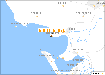
Santa Isabel (Andalucía, Spain)Santa Isabel is a town in the Andalucía region of Spain. An overview map of the region around Santa Isabel is displayed below.
regional and 3d topo map of Santa Isabel, Spain ::
nearby GPS traces from timatio ::
Santa Isabel airports ::
The nearest airport is XRY - Jerez, located 25.8 km north east of Santa Isabel.
Other airports nearby include OZP - Sevilla Moron Ab (87.7 km north east), GIB - Gibraltar (95.2 km south east), SVQ - Sevilla (98.5 km north), TNG - Tanger Ibn Batouta (100.0 km south), Nearby towns ::
Vista Hermosa (0.3km north) //
El Puerto de Santa María (3.6km north east) //
Cádiz (6.2km south west) //
Matagorda (7.5km south) //
San Felipe Neri (7.7km south) //
El Trocadero (7.9km south) //
Puntales (8.3km south) //
El Campillo (8.7km north west) //
[all distances 'as the bird flies' and approximate]  Places with similar names to Santa Isabel, Spain ::
// Santa Isabel (BR)
// Santa Isabel (BR)
// Santa Isabel (BR)
// Santa Isabel (BR)
// Santa Isabel (BR)
// Santa Isabel (BR)
// Santa Isabel (BR)
// Santa Isabel (BR)
// Santa Isabel (BR)
// Santa Isabel (BR)
Disclaimer :: Information on this page comes without warranty of any kind |
||
|
Where is Santa Isabel? Elevation and coordinates ::
Latitude (lat): 36°34'57"N Longitude (lon): 6°16'0"W
Elevation (approx.): 16m (map arrows pan, magnifying glasses zoom) |
||
|
Visiting Santa Isabel? Hotel/Accommodation ::
Book a hotel in Santa Isabel Travel Guide ::
Buy a travel guide for Spain rental cars ::
car rental offers GPS waypoint ::
download a GPX waypoint (PoI) of Santa Isabel for your GPS receiver
|
||