|
search place name
|
||
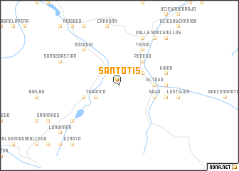
Santotís (Cantabria, Spain)Santotís is a town in the Cantabria region of Spain. An overview map of the region around Santotís is displayed below.
regional and 3d topo map of Santotís, Spain ::
Santotís airports ::
The nearest airport is SDR - Santander, located 50.7 km north east of Santotís.
Other airports nearby include BIO - Bilbao (116.5 km east), VIT - Vitoria (134.9 km east), OVD - Aviles Asturias (144.8 km west), VLL - Valladolid (167.8 km south), Nearby towns ::
Sarceda (2.3km north west) //
Llendemozo (3.3km north east) //
Fresneda (3.3km north east) //
Tudanca (3.3km south west) //
Renedo (4.6km north east) //
El Tojo (4.1km east) //
Saja (4.5km south east) //
La Lastra (4.5km south west) //
Terán (6.2km north east) //
Selores (6.2km north east) //
Correpoco (5.4km east) //
Viaña (5.7km east) //
Colsa (5.7km east) //
Rozadío (6.9km north west) //
Valle (7.9km north) //
Sopeña (8.4km north east) //
Lamiña (8.4km north east) //
Puente Pumar (7.8km south west) //
Barcenillas (9.2km north east) //
[all distances 'as the bird flies' and approximate]  Places with similar names to Santotís, Spain ::
Disclaimer :: Information on this page comes without warranty of any kind |
||
|
Where is Santotís? Elevation and coordinates ::
Latitude (lat): 43°10'0"N Longitude (lon): 4°20'0"W
Elevation (approx.): 960m (map arrows pan, magnifying glasses zoom) |
||
|
Visiting Santotís? Hotel/Accommodation ::
Book a hotel in Santotís Travel Guide ::
Buy a travel guide for Spain rental cars ::
car rental offers GPS waypoint ::
download a GPX waypoint (PoI) of Santotís for your GPS receiver
|
||