|
search place name
|
||
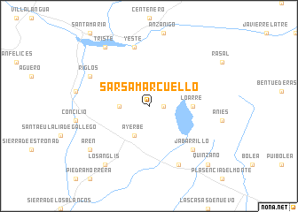
Sarsamarcuello (Aragón, Spain)Sarsamarcuello is a town in the Aragón region of Spain. An overview map of the region around Sarsamarcuello is displayed below.
regional and 3d topo map of Sarsamarcuello, Spain ::
Sarsamarcuello airports ::
The nearest airport is ZAZ - Zaragoza Ab, located 78.6 km south west of Sarsamarcuello.
Other airports nearby include PNA - Pamplona (94.9 km north west), LDE - Tarbes Lourdes (110.0 km north east), PUF - Pau Pyrenees (119.9 km north), BIQ - Biarritz-bayonne Anglet (145.8 km north west), Nearby towns ::
Santa Engracia (1.4km east) //
Linás de Marcuello (2.7km west) //
Ayerbe (4.0km south) //
Loarre (4.1km east) //
Yeste (7.5km north) //
Jabarrillo (6.9km south east) //
Riglos (6.6km north west) //
Loscorrales (7.9km south) //
Triste (8.5km north west) //
Arén (7.8km south west) //
Losanglis (8.5km south west) //
Quinzano (9.2km south east) //
[all distances 'as the bird flies' and approximate] 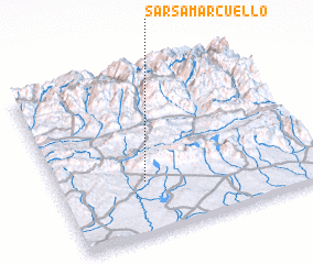 Places with similar names to Sarsamarcuello, Spain :: Disclaimer :: Information on this page comes without warranty of any kind |
||
|
Where is Sarsamarcuello? Elevation and coordinates ::
Latitude (lat): 42°19'0"N Longitude (lon): 0°40'0"W
Elevation (approx.): 897m (map arrows pan, magnifying glasses zoom) |
||
|
Visiting Sarsamarcuello? Hotel/Accommodation ::
Book a hotel in Sarsamarcuello Travel Guide ::
Buy a travel guide for Spain rental cars ::
car rental offers GPS waypoint ::
download a GPX waypoint (PoI) of Sarsamarcuello for your GPS receiver
|
||