|
search place name
|
||
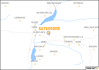
Suterraña (Cataluña, Spain)Suterraña is a town in the Cataluña region of Spain. An overview map of the region around Suterraña is displayed below.
regional and 3d topo map of Suterraña, Spain ::
Suterraña airports ::
The nearest airport is LEU - Seo De Urgel, located 43.3 km north east of Suterraña.
Other airports nearby include REU - Reus (112.8 km south), BCN - Barcelona (133.4 km south east), LDE - Tarbes Lourdes (138.6 km north west), LRH - La Rochelle Lherm (146.6 km north), Nearby towns ::
Vilamitjana (2.7km west) //
Gabet (4.0km south) //
Palau de Noguera (4.1km west) //
Tremp (4.5km north west) //
Figuerola de Orcau (4.5km south east) //
Sant Cerni (6.2km south west) //
Talarn (5.5km north west) //
Salás de Pallás (7.5km north) //
Aransís (7.5km south) //
Conques (6.6km south east) //
Guardia de Tremp (7.8km south west) //
[all distances 'as the bird flies' and approximate] 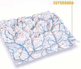 Places with similar names to Suterraña, Spain ::
Disclaimer :: Information on this page comes without warranty of any kind |
||
|
Where is Suterraña? Elevation and coordinates ::
Latitude (lat): 42°9'0"N Longitude (lon): 0°57'0"W
Elevation (approx.): 519m (map arrows pan, magnifying glasses zoom) |
||
|
Visiting Suterraña? Hotel/Accommodation ::
Book a hotel in Suterraña Travel Guide ::
Buy a travel guide for Spain rental cars ::
car rental offers GPS waypoint ::
download a GPX waypoint (PoI) of Suterraña for your GPS receiver
|
||