|
search place name
|
||
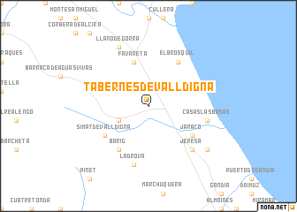
Tabernes de Valldigna (Comunidad Valenciana, Spain)Tabernes de Valldigna is a town in the Comunidad Valenciana region of Spain. An overview map of the region around Tabernes de Valldigna is displayed below.
regional and 3d topo map of Tabernes de Valldigna, Spain ::
Tabernes de Valldigna airports ::
The nearest airport is VLC - Valencia, located 50.5 km north of Tabernes de Valldigna.
Other airports nearby include ALC - Alicante (90.7 km south), IBZ - Ibiza (143.7 km east), MJV - Murcia San Javier (151.1 km south), Nearby towns ::
Benifairó de Valldigna (3.4km south west) //
Favareta (5.7km north) //
Bárig (6.3km south west) //
Jaraco (5.7km south east) //
Simat de Valldigna (5.7km south west) //
El Brosquil (6.3km north east) //
La Drova (7.6km south) //
Casas Las Basas (6.0km east) //
Jeresa (7.0km south east) //
Llano de Gorra (8.0km north) //
Caserío La Estación (8.0km south east) //
[all distances 'as the bird flies' and approximate] 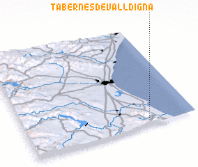 Places with similar names to Tabernes de Valldigna, Spain :: Disclaimer :: Information on this page comes without warranty of any kind |
||
|
Where is Tabernes de Valldigna? Elevation and coordinates ::
Latitude (lat): 39°4'0"N Longitude (lon): 0°16'0"W
Elevation (approx.): 14m (map arrows pan, magnifying glasses zoom) |
||
|
Visiting Tabernes de Valldigna? Hotel/Accommodation ::
Book a hotel in Tabernes de Valldigna Travel Guide ::
Buy a travel guide for Spain rental cars ::
car rental offers GPS waypoint ::
download a GPX waypoint (PoI) of Tabernes de Valldigna for your GPS receiver
|
||