|
search place name
|
||
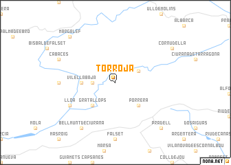
Torroja (Cataluña, Spain)Torroja is a town in the Cataluña region of Spain. An overview map of the region around Torroja is displayed below.
regional and 3d topo map of Torroja, Spain ::
Torroja airports ::
The nearest airport is REU - Reus, located 30.4 km east of Torroja.
Other airports nearby include BCN - Barcelona (106.1 km east), LEU - Seo De Urgel (134.0 km north), ZAZ - Zaragoza Ab (163.1 km west), GRO - Gerona Girona (179.1 km north east), Nearby towns ::
Vilella Alta (2.8km west) //
Poboleda (3.3km north east) //
Porrera (4.6km south east) //
Gratallops (4.6km south west) //
Vilella Baja (4.2km west) //
Lloá (6.7km south west) //
Bellmunt de Ciurana (8.5km south west) //
Pradell (9.3km south east) //
Margalef (9.3km north west) //
[all distances 'as the bird flies' and approximate] 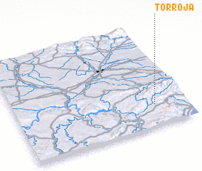 Places with similar names to Torroja, Spain ::
Disclaimer :: Information on this page comes without warranty of any kind |
||
|
Where is Torroja? Elevation and coordinates ::
Latitude (lat): 41°13'0"N Longitude (lon): 0°49'0"W
Elevation (approx.): 317m (map arrows pan, magnifying glasses zoom) |
||
|
Visiting Torroja? Hotel/Accommodation ::
Book a hotel in Torroja Travel Guide ::
Buy a travel guide for Spain rental cars ::
car rental offers GPS waypoint ::
download a GPX waypoint (PoI) of Torroja for your GPS receiver
|
||