|
search place name
|
||
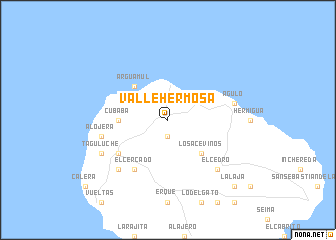
Vallehermosa (Canarias, Spain)Vallehermosa is a town in the Canarias region of Spain. An overview map of the region around Vallehermosa is displayed below.
regional and 3d topo map of Vallehermosa, Spain ::
Vallehermosa airports ::
The nearest airport is TFS - Tenerife Sur, located 67.9 km east of Vallehermosa.
Other airports nearby include SPC - Santa Cruz De La Palma La Palma (71.1 km north west), VDE - Hierro (73.8 km south west), TFN - Tenerife Norte (95.7 km east), LPA - Gran Canaria (185.0 km east), Nearby towns ::
Banda de las Rosas (1.9km south) //
Arguamul (4.9km north west) //
Los Aceviños (4.9km south east) //
Cubaba (4.9km west) //
El Cercado (6.4km south west) //
Acardece (6.1km south west) //
Agulo (6.8km east) //
Alojera (6.8km west) //
Arure (7.4km south west) //
El Cedro (7.4km south east) //
Taguluche (7.5km south west) //
La Laja (9.9km south east) //
[all distances 'as the bird flies' and approximate]  Places with similar names to Vallehermosa, Spain ::
// Villa Hermosa (BO)
// Valhermosa (ES)
// Valhermoso (ES)
// Villahermosa (ES)
// Villahormes (ES)
// Valle Hermoso (CL)
// Villa Hermosa (CO)
// Villa Hermosa (CO)
// Villa Hermosa (CO)
// Villa Hermosa (CO)
Disclaimer :: Information on this page comes without warranty of any kind |
||
|
Where is Vallehermosa? Elevation and coordinates ::
Latitude (lat): 28°10'0"N Longitude (lon): 17°15'0"W
Elevation (approx.): 561m (map arrows pan, magnifying glasses zoom) |
||
|
Visiting Vallehermosa? Hotel/Accommodation ::
Book a hotel in Vallehermosa Travel Guide ::
Buy a travel guide for Spain rental cars ::
car rental offers GPS waypoint ::
download a GPX waypoint (PoI) of Vallehermosa for your GPS receiver
|
||