|
search place name
|
||
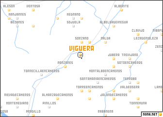
Viguera (La Rioja, Spain)Viguera is a town in the La Rioja region of Spain. An overview map of the region around Viguera is displayed below.
regional and 3d topo map of Viguera, Spain ::
Viguera airports ::
The nearest airport is VIT - Vitoria, located 66.6 km north of Viguera.
Other airports nearby include PNA - Pamplona (89.6 km north east), BIO - Bilbao (115.4 km north), EAS - San Sebastian (132.1 km north east), ZAZ - Zaragoza Ab (142.3 km south east), Nearby towns ::
Castañares de las Cuevas (2.3km north west) //
Sorzano (3.7km north) //
Islallana (4.0km north) //
Panzares (3.3km south west) //
Montalbo en Cameros (5.5km south east) //
Santa María en Cameros (6.2km south east) //
Nalda (5.5km north east) //
Jubera (5.5km east) //
Muro en Cameros (7.4km south) //
Luezas (5.8km east) //
Torre en Cameros (7.5km south) //
Sojuela (7.5km north) //
San Román de Cameros (9.2km south east) //
Albelda de Iregua (9.2km north east) //
[all distances 'as the bird flies' and approximate] 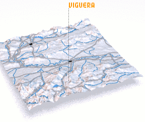 Places with similar names to Viguera, Spain ::
Disclaimer :: Information on this page comes without warranty of any kind |
||
|
Where is Viguera? Elevation and coordinates ::
Latitude (lat): 42°18'0"N Longitude (lon): 2°32'0"W
Elevation (approx.): 728m (map arrows pan, magnifying glasses zoom) |
||
|
Visiting Viguera? Hotel/Accommodation ::
Book a hotel in Viguera Travel Guide ::
Buy a travel guide for Spain rental cars ::
car rental offers GPS waypoint ::
download a GPX waypoint (PoI) of Viguera for your GPS receiver
|
||