|
search place name
|
||
Villar de Santos (Galicia, Spain)Villar de Santos is a town in the Galicia region of Spain. An overview map of the region around Villar de Santos is displayed below.
regional and 3d topo map of Villar de Santos, Spain ::

Villar de Santos airports ::
The nearest airport is VGO - Vigo, located 71.6 km west of Villar de Santos.
Other airports nearby include VRL - Vila Real (90.0 km south), BGC - Braganca (92.7 km east), SCQ - Santiago (104.2 km north west), OPO - Porto (119.2 km south west), Nearby towns ::
Couso de Limia (2.3km north east) //
Parada de Outeiro (2.3km north west) //
Las Lamas (4.6km south east) //
Sandianes (4.6km north east) //
Ganade (5.6km south) //
Rairiz de Veiga (4.1km west) //
Coedo (5.7km north) //
Sabariz (4.5km north west) //
Piñeira de Arriba (6.2km north east) //
Piñeira de Abajo (6.2km north east) //
Mosteiro (7.5km south) //
Sobreganade (7.5km south) //
Torneiros (7.5km north) //
Lampaza (5.8km west) //
Ginzo de Limia (6.6km south east) //
Sabucedo (7.9km south) //
Guillamil (6.6km north west) //
Damil (7.8km south east) //
Porquera (8.5km south west) //
Parada de Riveira (8.5km south east) //
Porquera (9.2km south west) //
[all distances 'as the bird flies' and approximate] 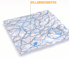 Places with similar names to Villar de Santos, Spain ::
// Villardecendías (ES)
Disclaimer :: Information on this page comes without warranty of any kind |
||
|
Where is Villar de Santos? Elevation and coordinates ::
Latitude (lat): 42°5'0"N Longitude (lon): 7°47'0"W
Elevation (approx.): 617m (map arrows pan, magnifying glasses zoom) |
||
|
Visiting Villar de Santos? Hotel/Accommodation ::
Book a hotel in Villar de Santos Travel Guide ::
Buy a travel guide for Spain rental cars ::
car rental offers GPS waypoint ::
download a GPX waypoint (PoI) of Villar de Santos for your GPS receiver
|
||