|
search place name
|
||
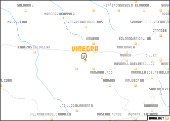
Viñegra (Castilla y León, Spain)Viñegra is a town in the Castilla y León region of Spain. An overview map of the region around Viñegra is displayed below.
regional and 3d topo map of Viñegra, Spain ::
Viñegra airports ::
The nearest airport is SLM - Salamanca, located 44.0 km north west of Viñegra.
Other airports nearby include VLL - Valladolid (113.7 km north), MAD - Madrid Barajas (131.8 km east), TOJ - Madrid Torrejon (141.8 km east), BGC - Braganca (186.2 km north west), Nearby towns ::
Blascojimeno (0.0km north) //
Gallegos de Sobrinos (1.9km north) //
Gamonal (2.3km south east) //
Hurtumpascual (2.3km south west) //
Mirueña (4.0km north) //
Manjabálago (4.7km south east) //
Ortigosa del Ríoalmar (4.6km south east) //
San García de Ingelmos (7.4km north) //
Grajos (7.0km south east) //
[all distances 'as the bird flies' and approximate]  Places with similar names to Viñegra, Spain ::
// Vinogora (RU)
// Fongara (IT)
// Vinagre (PA)
// Faniqueira (PT)
// Vinagra (PT)
// Vengriai (LT)
// Fuen Negra (ES)
// Fingri (BD)
// Ghongra (BD)
// Ghunkarah (BT)
Disclaimer :: Information on this page comes without warranty of any kind |
||
|
Where is Viñegra? Elevation and coordinates ::
Latitude (lat): 40°42'0"N Longitude (lon): 5°6'0"W
Elevation (approx.): 1205m (map arrows pan, magnifying glasses zoom) |
||
|
Visiting Viñegra? Hotel/Accommodation ::
Book a hotel in Viñegra Travel Guide ::
Buy a travel guide for Spain rental cars ::
car rental offers GPS waypoint ::
download a GPX waypoint (PoI) of Viñegra for your GPS receiver
|
||