|
search place name
|
||
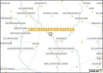
Zarzosa de Ríopisuerga (Castilla y León, Spain)Zarzosa de Ríopisuerga is a town in the Castilla y León region of Spain. An overview map of the region around Zarzosa de Ríopisuerga is displayed below.
regional and 3d topo map of Zarzosa de Ríopisuerga, Spain ::
Zarzosa de Ríopisuerga airports ::
The nearest airport is VLL - Valladolid, located 103.9 km south west of Zarzosa de Ríopisuerga.
Other airports nearby include SDR - Santander (105.8 km north), VIT - Vitoria (132.2 km east), BIO - Bilbao (139.8 km north east), OVD - Aviles Asturias (184.0 km north west), Nearby towns ::
Hinojal de Ríopisuerga (2.3km north west) //
Castrillo de Ríopisuerga (2.3km south east) //
Rezmondo (3.3km south east) //
Olmos de Pisuerga (5.6km south) //
Hijosa (5.5km south west) //
Valtierra de Ríopisuerga (6.2km south east) //
Sotovellanos (7.4km north) //
Naveros de Pisuerga (7.5km south) //
Quintanilla de Ríofresno (5.8km east) //
Barrio de San Felices (5.8km east) //
Tagarrosa (7.8km south east) //
Santa María-Ananúñez (7.8km south east) //
Herrera de Pisuerga (9.2km north west) //
Salazar de Amaya (9.2km north east) //
[all distances 'as the bird flies' and approximate] 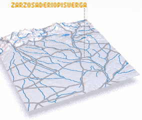 Places with similar names to Zarzosa de Ríopisuerga, Spain :: Disclaimer :: Information on this page comes without warranty of any kind |
||
|
Where is Zarzosa de Ríopisuerga? Elevation and coordinates ::
Latitude (lat): 42°32'0"N Longitude (lon): 4°16'0"W
Elevation (approx.): 819m (map arrows pan, magnifying glasses zoom) |
||
|
Visiting Zarzosa de Ríopisuerga? Hotel/Accommodation ::
Book a hotel in Zarzosa de Ríopisuerga Travel Guide ::
Buy a travel guide for Spain rental cars ::
car rental offers GPS waypoint ::
download a GPX waypoint (PoI) of Zarzosa de Ríopisuerga for your GPS receiver
|
||