|
search place name
|
||
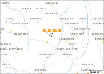
Kgoroshi (South Africa)Kgoroshi is a town in South Africa. An overview map of the region around Kgoroshi is displayed below.
regional and 3d topo map of Kgoroshi, South Africa ::
Kgoroshi airports ::
The nearest airport is PTG - Pietersburg, located 36.0 km south east of Kgoroshi.
Other airports nearby include LTA - Tzaneen (111.1 km east), PHW - Phalaborwa (196.2 km east), HDS - Hoedspruit Afb (198.1 km south east), PKW - Selebi-phikwe Selebi Phikwe (231.6 km north west), Nearby towns ::
Ditenteng (2.5km north west) //
Manamela (2.5km south west) //
Mahwibitswane (5.4km east) //
Monywaneng (7.4km north) //
Ramakgaphola (7.6km south) //
Mmadigorong (7.5km north east) //
Locatie van Malietzie (7.5km south east) //
Ga-Modikana (7.5km north west) //
Masobohleng (7.7km north east) //
Koloti (7.7km south east) //
Ga-Komape (9.0km south east) //
[all distances 'as the bird flies' and approximate] 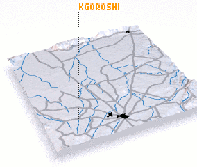 Places with similar names to Kgoroshi, South Africa ::
// Cucaracha (PA)
// Gakruchey (RU)
// Kugarchi (RU)
// Kugarchi (RU)
// Kāchrāish (BD)
// Cucaracha (CR)
// Cucurucho (SV)
// Cuquiarachi (MX)
// Guacarichi (MX)
// Cucurucho (HN)
Disclaimer :: Information on this page comes without warranty of any kind |
||
|
Where is Kgoroshi? Elevation and coordinates ::
Latitude (lat): 23°41'0"S Longitude (lon): 29°15'0"E
Elevation (approx.): 1229m (map arrows pan, magnifying glasses zoom) |
||
|
Visiting Kgoroshi? Hotel/Accommodation ::
Book a hotel in Kgoroshi Travel Guide ::
rental cars ::
car rental offers GPS waypoint ::
download a GPX waypoint (PoI) of Kgoroshi for your GPS receiver
|
||