|
search place name
|
||
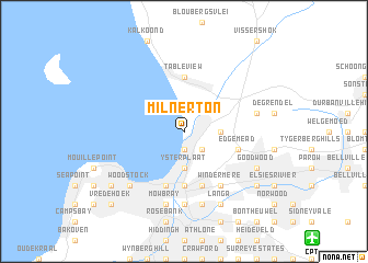
Milnerton (South Africa)Milnerton is a town in South Africa. An overview map of the region around Milnerton is displayed below.
regional and 3d topo map of Milnerton, South Africa ::
Milnerton airports ::
The nearest airport is CPT - Cape Town Intl, located 15.4 km south east of Milnerton.
Nearby towns ::
Zonnekus (1.9km south) //
Sanddrift (2.4km south east) //
Ysterplaat (3.7km south) //
Rugby (3.7km south) //
Montague Gardens (3.1km east) //
Brooklyn (5.6km south) //
Table View (5.6km north) //
Edgemead (5.0km east) //
Paardeneiland (5.8km south) //
Pinelands (5.8km south) //
Kensington (5.8km south) //
Windermere (6.4km south east) //
Garden Village (7.4km south) //
Observatory (7.6km south) //
Soutrivier (7.6km south) //
Mowbray (7.6km south) //
Maitland (7.6km south) //
Bothasig (6.4km east) //
Woodstock (7.2km south west) //
Roggebaai (7.2km south west) //
Langa (8.0km south east) //
Goodwood (7.2km south east) //
Cape Town (8.3km south west) //
Schotschekloof (8.3km south west) //
Malay Quarter (8.3km south west) //
Vasco (8.3km south east) //
Epping (8.3km south east) //
Vredehoek (9.6km south west) //
Oranjezicht (9.6km south west) //
[all distances 'as the bird flies' and approximate]  Places with similar names to Milnerton, South Africa :: Disclaimer :: Information on this page comes without warranty of any kind |
||
|
Where is Milnerton? Elevation and coordinates ::
Latitude (lat): 33°52'0"S Longitude (lon): 18°29'0"E
Elevation (approx.): -32768m (map arrows pan, magnifying glasses zoom) |
||
|
Visiting Milnerton? Hotel/Accommodation ::
Book a hotel in Milnerton Travel Guide ::
rental cars ::
car rental offers GPS waypoint ::
download a GPX waypoint (PoI) of Milnerton for your GPS receiver
|
||