|
search place name
|
||
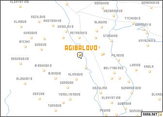
Agibalovo (Smolenskaya Oblast', Russia)Agibalovo is a town in the Smolenskaya Oblast' region of Russia. An overview map of the region around Agibalovo is displayed below.
regional and 3d topo map of Agibalovo, Russia ::
Nearby towns ::
Rodionovo (2.2km south) //
Petrenino (4.8km north) //
Shcherbatovshchina (3.5km north east) //
Katelka (2.8km east) //
Klinkovo (4.8km south) //
Verkhneye Mosolovo (3.1km east) //
Yeryutino (5.1km north) //
Kharitonovka (5.3km north west) //
Veselëvo (6.5km north) //
Chernënovo (6.6km north) //
Gorodok (6.9km south) //
Isakovo (5.7km south west) //
Stëshino (5.6km north east) //
Belyy Bereg (5.4km south east) //
Kharino (6.0km south east) //
Alad'ino (7.7km north) //
Fil'nevo (4.9km east) //
Kozulino (8.3km south) //
Ivashkovo (5.6km south west) //
Veretenino (6.6km north west) //
Nizhneye Mosolovo (6.7km south east) //
Pustoshka (8.4km north west) //
[all distances 'as the bird flies' and approximate]  Places with similar names to Agibalovo, Russia ::
// Agibalovo (RU)
Disclaimer :: Information on this page comes without warranty of any kind |
||
|
Where is Agibalovo? Elevation and coordinates ::
Latitude (lat): 55°24'26"N Longitude (lon): 33°30'15"E
Elevation (approx.): 192m (map arrows pan, magnifying glasses zoom) |
||
|
Visiting Agibalovo? Hotel/Accommodation ::
Book a hotel in Agibalovo Travel Guide ::
Buy a travel guide for Russia rental cars ::
car rental offers GPS waypoint ::
download a GPX waypoint (PoI) of Agibalovo for your GPS receiver
|
||