|
search place name
|
||
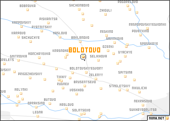
Bolotovo (Orlovskaya Oblast', Russia)Bolotovo is a town in the Orlovskaya Oblast' region of Russia. An overview map of the region around Bolotovo is displayed below.
regional and 3d topo map of Bolotovo, Russia ::
Bolotovo airports ::
The nearest airport is BZK - Bryansk, located 116.5 km west of Bolotovo.
Nearby towns ::
Bolotovskiye Dvory (2.6km south) //
Selikhova (1.8km east) //
Yuzhnyy (3.2km south west) //
Krasnomezenskiy (2.7km north west) //
Baklanovo (4.2km north) //
Krasnyy (2.7km west) //
Zelënyy (4.3km south) //
Yasnaya Polyana (4.3km south west) //
Ozërki (3.7km north east) //
Brusentsevo (5.6km south) //
Prudki (4.1km east) //
Maloye Sotnikovo (4.2km south west) //
Tikhiy (5.5km south west) //
Volaboyevo (6.5km south) //
Posëlok Bol'shoye Sotnikovo (5.5km south west) //
Malyy Pakhomov (4.4km east) //
Red'kino (6.2km north east) //
Maslovo (6.2km north west) //
Savinkova (5.6km north east) //
Voskhod (7.5km south) //
Yevdokimova (4.7km east) //
Rudnëv (6.7km south west) //
Maleyevka (7.8km north) //
D'yach'ye (5.4km east) //
Krest'yanin (8.0km south west) //
Streletskiy (7.9km south east) //
Piskanitsa (9.6km north west) //
[all distances 'as the bird flies' and approximate]  Places with similar names to Bolotovo, Russia ::
Disclaimer :: Information on this page comes without warranty of any kind |
||
|
Where is Bolotovo? Elevation and coordinates ::
Latitude (lat): 53°4'20"N Longitude (lon): 35°54'7"E
Elevation (approx.): 180m (map arrows pan, magnifying glasses zoom) |
||
|
Visiting Bolotovo? Hotel/Accommodation ::
Book a hotel in Bolotovo Travel Guide ::
Buy a travel guide for Russia rental cars ::
car rental offers GPS waypoint ::
download a GPX waypoint (PoI) of Bolotovo for your GPS receiver
|
||