|
search place name
|
||
Bol'shoy Ostrov (Leningradskaya Oblast', Russia)Bol'shoy Ostrov is a town in the Leningradskaya Oblast' region of Russia. An overview map of the region around Bol'shoy Ostrov is displayed below.
regional and 3d topo map of Bol'shoy Ostrov, Russia ::
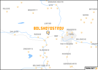
Nearby towns ::
Malyy Ostrov (0.9km south) //
Mezhurech'ye (2.2km south west) //
Bor (2.1km south east) //
Lar'yan (3.3km north) //
Borovatoye (3.8km south) //
Russ'ka (2.3km west) //
Khristovo (2.7km east) //
Sergeyevo (4.7km south) //
Sergeyevskaya Baza (4.7km south) //
Krutik (3.6km east) //
Boksitogorsk (3.6km east) //
Slavkovo (6.9km south) //
Tretiy Rudnik (5.8km south east) //
Moshnya (8.3km south) //
Selishche (8.1km south) //
Topol' (4.5km east) //
Podsosna (4.6km east) //
Nosovo (8.6km south) //
Zaozër'ye (7.6km south west) //
Bagernyy (8.9km north) //
Mikhnovo (9.0km south east) //
[all distances 'as the bird flies' and approximate] 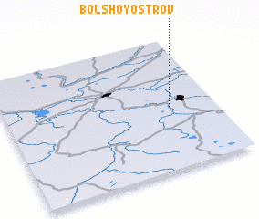 Places with similar names to Bol'shoy Ostrov, Russia ::
// Bol'shaya Sidorova (RU)
// Bol'shiye Ostrova (RU)
// Bol'shoye Sidorovo (RU)
// Bol'shoy Ostrov (RU)
// Bol'shoy Ostrov (RU)
Disclaimer :: Information on this page comes without warranty of any kind |
||
|
Where is Bol'shoy Ostrov? Elevation and coordinates ::
Latitude (lat): 59°28'28"N Longitude (lon): 33°47'16"E
Elevation (approx.): 93m (map arrows pan, magnifying glasses zoom) |
||
|
Visiting Bol'shoy Ostrov? Hotel/Accommodation ::
Book a hotel in Bol'shoy Ostrov Travel Guide ::
Buy a travel guide for Russia rental cars ::
car rental offers GPS waypoint ::
download a GPX waypoint (PoI) of Bol'shoy Ostrov for your GPS receiver
|
||