|
search place name
|
||
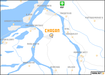
Chagan (Astrakhanskaya Oblast', Russia)Chagan is a town in the Astrakhanskaya Oblast' region of Russia. An overview map of the region around Chagan is displayed below.
regional and 3d topo map of Chagan, Russia ::
Chagan airports ::
The nearest airport is ASF - Astrakhan, located 12.3 km north of Chagan.
Nearby towns ::
Atal (4.2km north east) //
Volgo-Kaspiyskiy (5.4km north west) //
Kargovskiy (4.9km east) //
Nikol'skoye (5.8km south west) //
Krasnyye Barrikady (6.0km north west) //
Tatarskaya Bashmakovka (8.4km north) //
Yaksatovo (8.2km north east) //
Sadovyy (8.7km north west) //
Il'inka (9.0km north west) //
[all distances 'as the bird flies' and approximate]  Places with similar names to Chagan, Russia ::
Disclaimer :: Information on this page comes without warranty of any kind |
||
|
Where is Chagan? Elevation and coordinates ::
Latitude (lat): 46°10'28"N Longitude (lon): 47°58'29"E
Elevation (approx.): -23m (map arrows pan, magnifying glasses zoom) |
||
|
Visiting Chagan? Hotel/Accommodation ::
Book a hotel in Chagan Travel Guide ::
Buy a travel guide for Russia rental cars ::
car rental offers GPS waypoint ::
download a GPX waypoint (PoI) of Chagan for your GPS receiver
|
||