|
search place name
|
||
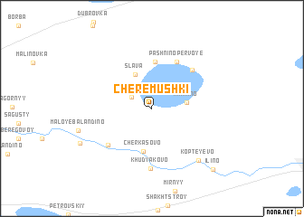
Cherëmushki (Chelyabinskaya Oblast', Russia)Cherëmushki is a town in the Chelyabinskaya Oblast' region of Russia. An overview map of the region around Cherëmushki is displayed below.
regional and 3d topo map of Cherëmushki, Russia ::
Cherëmushki airports ::
The nearest airport is CEK - Chelyabinsk Balandino, located 14.0 km west of Cherëmushki.
Other airports nearby include SVX - Sverdlovsk Koltsovo (166.1 km north), Nearby towns ::
Lazurnyy (2.0km north west) //
Kharino (2.6km east) //
Slava (4.3km north) //
Cherkasovo (5.3km south) //
Novyy (5.7km north) //
Pashnino Pervoye (6.0km north) //
Pashnino Vtoroye (5.6km north east) //
Starikovo (5.5km south west) //
Khudyakovo (7.5km south) //
Kopteyevo (7.2km south east) //
Sychëvo (6.6km south west) //
Il'ino (8.7km south east) //
[all distances 'as the bird flies' and approximate] 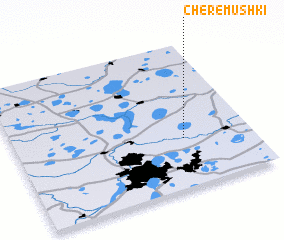 Places with similar names to Cherëmushki, Russia ::
// Cherëmushka (UA)
// Cherëmoshka (RU)
// Cherëmushka (RU)
// Cherëmushka (RU)
// Cherëmushka (RU)
// Cherëmushka (RU)
// Cherëmushka (RU)
// Cherëmushka (RU)
// Cherëmushka (RU)
// Cherëmushka (RU)
Disclaimer :: Information on this page comes without warranty of any kind |
||
|
Where is Cherëmushki? Elevation and coordinates ::
Latitude (lat): 55°20'28"N Longitude (lon): 61°42'55"E
Elevation (approx.): 216m (map arrows pan, magnifying glasses zoom) |
||
|
Visiting Cherëmushki? Hotel/Accommodation ::
Book a hotel in Cherëmushki Travel Guide ::
Buy a travel guide for Russia rental cars ::
car rental offers GPS waypoint ::
download a GPX waypoint (PoI) of Cherëmushki for your GPS receiver
|
||