|
search place name
|
||
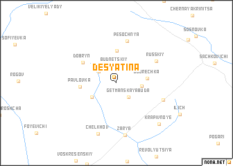
Desyatina (Bryanskaya Oblast', Russia)Desyatina is a town in the Bryanskaya Oblast' region of Russia. An overview map of the region around Desyatina is displayed below.
regional and 3d topo map of Desyatina, Russia ::
Desyatina airports ::
The nearest airport is GME - Gomel, located 76.4 km west of Desyatina.
Other airports nearby include KBP - Kiev Boryspil Intl (234.4 km south), IEV - Kiev Zhuliany Intl (241.5 km south west), Nearby towns ::
Budnetskiy (2.8km north) //
Getmanskaya Buda (2.6km south east) //
Vorob'yëvka (2.5km north west) //
Igryanov (2.5km east) //
Trubëzh (3.3km south west) //
Dobrechka (3.1km east) //
Lebedin (5.2km north) //
Pavlovka (3.7km west) //
Dobryn' (4.7km north west) //
Pesochnya (6.8km north) //
Russkiy (5.3km north east) //
Dvenadtsatidvorka (5.4km south east) //
Zarya (8.5km south) //
Chelkhov (8.4km south) //
Krapivnoye (7.9km south east) //
[all distances 'as the bird flies' and approximate] 
Disclaimer :: Information on this page comes without warranty of any kind |
||
|
Where is Desyatina? Elevation and coordinates ::
Latitude (lat): 52°18'56"N Longitude (lon): 32°5'7"E
Elevation (approx.): 168m (map arrows pan, magnifying glasses zoom) |
||
|
Visiting Desyatina? Hotel/Accommodation ::
Book a hotel in Desyatina Travel Guide ::
Buy a travel guide for Russia rental cars ::
car rental offers GPS waypoint ::
download a GPX waypoint (PoI) of Desyatina for your GPS receiver
|
||