|
search place name
|
||
Durkovo (Yaroslavskaya Oblast', Russia)Durkovo is a town in the Yaroslavskaya Oblast' region of Russia. An overview map of the region around Durkovo is displayed below.
regional and 3d topo map of Durkovo, Russia ::
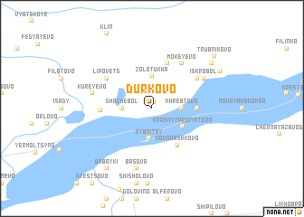
Nearby towns ::
Bor (0.8km north) //
Shachebol (2.0km west) //
Khrebtovo (2.0km east) //
Yurosha (2.0km east) //
Rybnitsy (3.7km south) //
Zolotukha (4.0km north) //
Krasnyy Profintern (3.0km south east) //
Novodashkovo (4.8km south) //
Yasnishche (3.0km east) //
Stroykovo (5.6km north) //
Chupriyanovo (5.6km north) //
Minino (5.6km north) //
Yakhrobol (3.4km west) //
Lipovets (4.7km north west) //
Mokeyevo (5.9km north) //
Timonino (4.7km north east) //
Iskrobol (5.0km north east) //
Kureyevo (4.4km north west) //
Basova (7.5km south) //
Babayki (8.0km south) //
Semidvor'ye (6.8km north east) //
Makarovo (6.4km north east) //
Trubnikovo (7.7km north east) //
[all distances 'as the bird flies' and approximate] 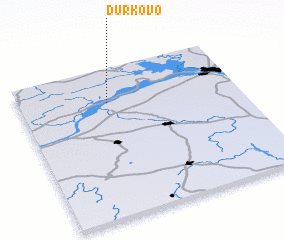 Places with similar names to Durkovo, Russia ::
Disclaimer :: Information on this page comes without warranty of any kind |
||
|
Where is Durkovo? Elevation and coordinates ::
Latitude (lat): 57°46'0"N Longitude (lon): 40°24'0"E
Elevation (approx.): 91m (map arrows pan, magnifying glasses zoom) |
||
|
Visiting Durkovo? Hotel/Accommodation ::
Book a hotel in Durkovo Travel Guide ::
Buy a travel guide for Russia rental cars ::
car rental offers GPS waypoint ::
download a GPX waypoint (PoI) of Durkovo for your GPS receiver
|
||