|
search place name
|
||
Galatli (Dagestan, Russia)Galatli is a town in the Dagestan region of Russia. An overview map of the region around Galatli is displayed below.
regional and 3d topo map of Galatli, Russia ::

Galatli airports ::
The nearest airport is MCX - Makhachkala Uytash, located 155.9 km north east of Galatli.
Nearby towns ::
Derikh (1.3km south east) //
Mokok (2.8km south) //
Khebatli (2.7km east) //
Tsibari (4.1km south) //
Takkho (4.6km south) //
Shauri (4.3km south east) //
Azilta (4.8km south east) //
(( Asakha )) (6.0km south) //
Otsikh (6.2km south) //
Itsirakh (6.0km south west) //
Tlyatsuda (7.1km north) //
Shapikh (7.5km south) //
Khamaitli (6.1km north east) //
Chalyakh (6.9km south west) //
Akdy (6.4km south west) //
Khenokh (6.5km south east) //
(( Renok )) (8.2km north) //
Khalakh (7.8km south west) //
Retlob (7.2km south west) //
Chatli (6.9km south west) //
Ikha (7.0km south west) //
Asakh (7.0km west) //
(( Tindy )) (7.2km north west) //
Khetokh (7.4km south east) //
Gutatli (9.4km south) //
Tsitsimakh (9.7km south west) //
Zinduk (9.6km south west) //
[all distances 'as the bird flies' and approximate] 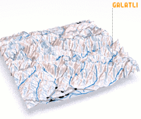 Places with similar names to Galatli, Russia ::
Disclaimer :: Information on this page comes without warranty of any kind |
||
|
Where is Galatli? Elevation and coordinates ::
Latitude (lat): 42°17'13"N Longitude (lon): 45°53'40"E
Elevation (approx.): 1975m (map arrows pan, magnifying glasses zoom) |
||
|
Visiting Galatli? Hotel/Accommodation ::
Book a hotel in Galatli Travel Guide ::
Buy a travel guide for Russia rental cars ::
car rental offers GPS waypoint ::
download a GPX waypoint (PoI) of Galatli for your GPS receiver
|
||