|
search place name
|
||
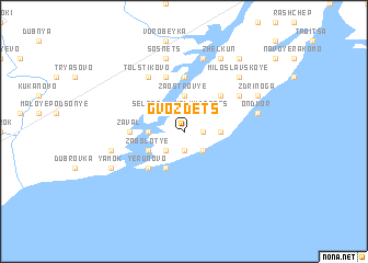
Gvozdets (Novgorodskaya Oblast', Russia)Gvozdets is a town in the Novgorodskaya Oblast' region of Russia. An overview map of the region around Gvozdets is displayed below.
regional and 3d topo map of Gvozdets, Russia ::
Gvozdets airports ::
The nearest airport is LED - St. Petersburg Pulkovo, located 167.6 km north of Gvozdets.
Nearby towns ::
Kuritsko (1.9km south) //
Desyatiny (1.0km east) //
Khotyazh (2.1km north west) //
Bol'shoy Donets (2.1km north east) //
Karpovo (2.1km north east) //
Malyy Donets (2.1km north east) //
Lipitsy (2.1km south west) //
Navolok (2.1km south east) //
Zaostrov'ye (3.7km north) //
Lyuboyazhi (1.9km west) //
Spaspiskopets (1.9km east) //
Klopskaya Sloboda (2.7km north west) //
Sel'tso (2.7km north west) //
Lukinshchino (2.7km north east) //
Goroshkovo (2.7km south west) //
Zabolot'ye (2.7km south west) //
Yarovitsy (3.8km south) //
Neronov Bor (4.2km north east) //
Yerunovo (4.2km south west) //
Khramzino (5.6km north) //
Zaval (2.9km west) //
Georgiy (5.6km north) //
Staroye Kuravichino (5.6km north) //
Tabol' (5.9km north) //
Tolstikovo (5.9km north) //
Samokrazha (4.7km north east) //
Sosnets (7.5km north) //
Gorki (7.5km north) //
Moiseyevichi (7.5km north) //
[all distances 'as the bird flies' and approximate] 
Disclaimer :: Information on this page comes without warranty of any kind |
||
|
Where is Gvozdets? Elevation and coordinates ::
Latitude (lat): 58°22'0"N Longitude (lon): 31°9'0"E
Elevation (approx.): 23m (map arrows pan, magnifying glasses zoom) |
||
|
Visiting Gvozdets? Hotel/Accommodation ::
Book a hotel in Gvozdets Travel Guide ::
Buy a travel guide for Russia rental cars ::
car rental offers GPS waypoint ::
download a GPX waypoint (PoI) of Gvozdets for your GPS receiver
|
||