|
search place name
|
||
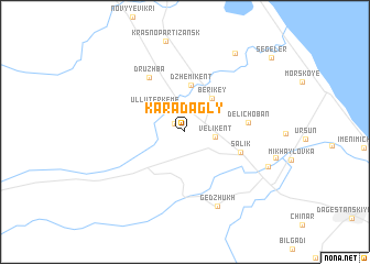
Karadagly (Dagestan, Russia)Karadagly is a town in the Dagestan region of Russia. An overview map of the region around Karadagly is displayed below.
regional and 3d topo map of Karadagly, Russia ::
Karadagly airports ::
The nearest airport is MCX - Makhachkala Uytash, located 76.2 km north west of Karadagly.
Nearby towns ::
Tatlyar (1.2km north west) //
Velikent (2.4km east) //
Ulluterkeme (3.3km north west) //
Berikey (3.9km north east) //
Dzhemikent (4.7km north) //
Salik (4.7km south east) //
Delichoban (4.8km east) //
Druzhba (6.1km north west) //
Gedzhukh (7.9km south) //
Kala (7.2km south east) //
Ismailkutan (8.8km north east) //
Segeler (10.0km north east) //
[all distances 'as the bird flies' and approximate]  Places with similar names to Karadagly, Russia ::
Disclaimer :: Information on this page comes without warranty of any kind |
||
|
Where is Karadagly? Elevation and coordinates ::
Latitude (lat): 42°11'33"N Longitude (lon): 48°2'12"E
Elevation (approx.): 75m (map arrows pan, magnifying glasses zoom) |
||
|
Visiting Karadagly? Hotel/Accommodation ::
Book a hotel in Karadagly Travel Guide ::
Buy a travel guide for Russia rental cars ::
car rental offers GPS waypoint ::
download a GPX waypoint (PoI) of Karadagly for your GPS receiver
|
||